
File:Japanese Empire2.png
Size of this preview: 515 × 599 pixels. Other resolutions: 206 × 240 pixels | 412 × 480 pixels | 660 × 768 pixels | 1,032 × 1,201 pixels.
Original file (1,032 × 1,201 pixels, file size: 927 KB, MIME type: image/png)
| This is a file from the Wikimedia Commons. Information from its description page there is shown below. Commons is a freely licensed media file repository. You can help. |

|
This military map image could be re-created using vector graphics as an SVG file. This has several advantages; see Commons:Media for cleanup for more information. If an SVG form of this image is available, please upload it and afterwards replace this template with
{{vector version available|new image name}}.
It is recommended to name the SVG file “Japanese Empire2.svg”—then the template Vector version available (or Vva) does not need the new image name parameter. |
Summary
| Description |
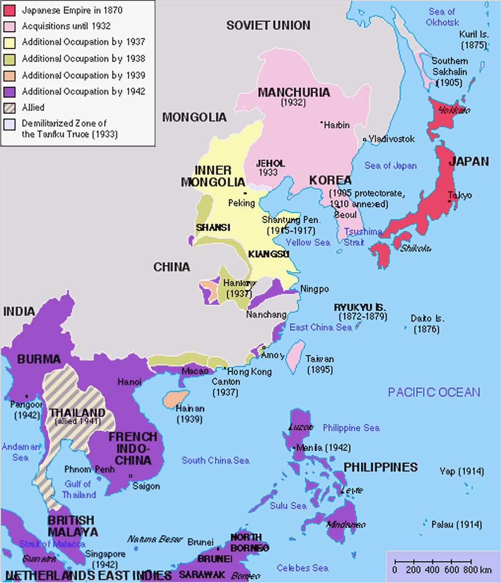
English: Original map was created by Kokiri, based in part on File:BlankMap-World.png. Subsequent modifications to colors performed by Huhsunqu. Additional corrections (fixed Ryukyu Islands, Sichuan, grammar in table) by Markalexander100. |
||||||||
| Date | (original upload date at English Wikipedia) | ||||||||
| Source |
This file was derived from: Japanese Empire.png |
||||||||
| Author | Kokiri at English Wikipedia, modifications by Huhsunqu and Markalexander100. | ||||||||
| Permission (Reusing this file) |
|
||||||||
| Other versions |
Derivative works of this file: |

.png)
Original upload log
The original upload log was here. The usernames refer to the English Wikipedia. Not to be confused with File:Japanese empire.png.
04:00, 6 October 2005 . . Huhsunqu (talk | contribs | block) 508 × 591 (44,305 bytes)02:42, 21 August 2004 . . Nanshu (talk | contribs | block) 508 × 591 (45,178 bytes)09:38, 18 August 2004 . . Kokiri (talk | contribs | block) 508 × 591 (46,867 bytes) (map of the Japanese Empire, drawn myself)
File history
Click on a date/time to view the file as it appeared at that time.
| Date/Time | Thumbnail | Dimensions | User | Comment | |
|---|---|---|---|---|---|
| current | 12:26, 3 March 2023 | | 1,032 × 1,201 (927 KB) | Hohum | Brighten |
| 12:24, 3 March 2023 |  | 1,032 × 1,201 (944 KB) | Hohum | less garish colours | |
| 03:53, 10 January 2023 |  | 1,032 × 1,201 (1,020 KB) | Artanisen | Added allied color. Thailand was in a coerced alliance (1941) thus part of the empire | |
| 06:20, 22 June 2022 |  | 1,032 × 1,201 (683 KB) | Crab2814 | Removed Tongking- France gave Japan military access to that region in 1940, not an occupational right. Fixed Sakhalin and Hainan. Removed Thailand, which was allied not occupied by Japan. | |
| 11:58, 3 August 2020 |  | 1,437 × 1,201 (1.8 MB) | Artanisen | Bigger size and sharper version of the same map. The rest is the same. | |
| 11:47, 5 July 2007 |  | 707 × 591 (32 KB) | Mahahahaneapneap | pngcrushed | |
| 01:31, 27 May 2007 |  | 707 × 591 (48 KB) | Gryffindor | {{svg}} {{GFDL}} Modified version of Image:Japanese_Empire.png. Fixed Ryukyu Islands, Sichuan, grammar in table. Category:Maps of the history of Japan Category:Maps of the history of Korea Category:Maps of the history of Vietnam [[Categ | |
| 15:13, 27 February 2007 |  | 508 × 591 (36 KB) | Cristan | Optimized using PNGOUT | |
| 11:24, 22 December 2005 |  | 508 × 591 (47 KB) | Markalexander100 | {{GFDL}} Modified version of Image:Japanese_Empire.png. Fixed Ryukyu Islands, Sichuan, grammar in table. |
File usage
There are no pages that use this file.
Global file usage
The following other wikis use this file:
- Usage on af.wikipedia.org
- Usage on ar.wikipedia.org
- Usage on ca.wikipedia.org
- Usage on cs.wikipedia.org
- Usage on de.wikipedia.org
- Usage on en.wikipedia.org
- Usage on eu.wikipedia.org
- Usage on fa.wikipedia.org
- Usage on fi.wikipedia.org
- Usage on fr.wikipedia.org
- Usage on gl.wikipedia.org
- Usage on hak.wikipedia.org
- Usage on he.wikipedia.org
- Usage on hy.wikipedia.org
- Usage on it.wikipedia.org
- Usage on ja.wikipedia.org
- Usage on min.wikipedia.org
- Usage on mk.wikipedia.org
- Usage on ms.wikipedia.org
- Usage on nl.wikipedia.org
- Usage on oc.wikipedia.org
- Usage on pam.wikipedia.org
- Usage on pt.wikipedia.org
- Usage on ro.wikipedia.org
View more global usage of this file.