
File:Kuster Mill.JPG

Size of this preview: 800 × 600 pixels. Other resolutions: 320 × 240 pixels | 640 × 480 pixels | 1,024 × 768 pixels | 1,280 × 960 pixels | 2,560 × 1,920 pixels | 4,271 × 3,203 pixels.
Original file (4,271 × 3,203 pixels, file size: 4.48 MB, MIME type: image/jpeg)
| This is a file from the Wikimedia Commons. Information from its description page there is shown below. Commons is a freely licensed media file repository. You can help. |
|
This is an image of a place or building that is listed on the National Register of Historic Places in the United States of America. Its reference number is 71000711. |
Summary
| Description |
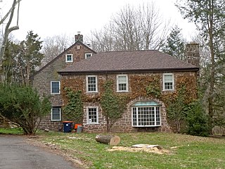
English: Kuster Mill on the NRHP since March 24, 1971. On Skippack Creek at Mill Road and Water Street Road, in Montgomery County, Pennsylvania south of Collegeville. A pedestrian bridge (now being repaired) leads into Evansburg State Park. Note that there is a Kuyster Mill in the park (on the other side of the creek to the west), but that this IS the Kuster Mill - it might also be called the Custer Mill because the family changed the spelling of the name. built in 1702, sold to Hermanus Custer in 1706, expanded by John Custer 1767. A later fulling mill was built, then burned down in 1936. It has been reconstructed and may be th part with the hipped roof shown in front here. |
| Date | |
| Source | Own work |
| Author | Smallbones |
| Camera location | | View this and other nearby images on: OpenStreetMap |
|---|
Licensing
I, the copyright holder of this work, hereby publish it under the following license:
| This file is made available under the Creative Commons CC0 1.0 Universal Public Domain Dedication. | |
| The person who associated a work with this deed has dedicated the work to the public domain by waiving all of their rights to the work worldwide under copyright law, including all related and neighboring rights, to the extent allowed by law. You can copy, modify, distribute and perform the work, even for commercial purposes, all without asking permission.
|
File history
Click on a date/time to view the file as it appeared at that time.
| Date/Time | Thumbnail | Dimensions | User | Comment | |
|---|---|---|---|---|---|
| current | 18:19, 8 April 2011 | | 4,271 × 3,203 (4.48 MB) | Smallbones | {{Information |Description ={{en|1=Kuster Mill on the NRHP since March 24, 1971. On Skippack Creek at Mill Road and Water Street Road, in Montgomery County, Pennsylvania south of Collegeville. A pedestrian bridge (now being repaired) leads into Evansb |
File usage
The following 2 pages use this file:
Global file usage
The following other wikis use this file:
- Usage on cy.wikipedia.org
- Usage on en.wikipedia.org
- Usage on en.wikivoyage.org
- Usage on es.wikipedia.org
- Usage on fr.wikipedia.org
- Usage on it.wikipedia.org
- Usage on uk.wikipedia.org
- Usage on vi.wikipedia.org
- Usage on www.wikidata.org