
File:LocationEurasia.png

Size of this preview: 800 × 407 pixels. Other resolutions: 320 × 163 pixels | 640 × 326 pixels | 1,024 × 521 pixels | 1,280 × 651 pixels | 2,759 × 1,404 pixels.
Original file (2,759 × 1,404 pixels, file size: 99 KB, MIME type: image/png)
| This is a file from the Wikimedia Commons. Information from its description page there is shown below. Commons is a freely licensed media file repository. You can help. |
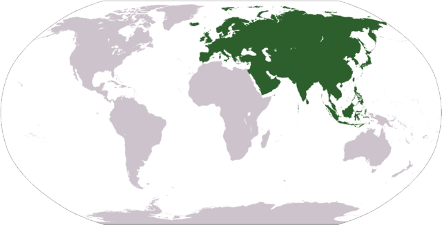
World map depicting Eurasia; map adapted from PDF world map at CIA World Fact Book
This image is in the public domain because it contains materials that originally came from the United States Central Intelligence Agency's World Factbook.
|
 |
File history
Click on a date/time to view the file as it appeared at that time.
| Date/Time | Thumbnail | Dimensions | User | Comment | |
|---|---|---|---|---|---|
| current | 12:33, 19 January 2008 | | 2,759 × 1,404 (99 KB) | F l a n k e r | Transparency |
| 13:53, 1 October 2006 |  | 2,759 × 1,404 (55 KB) | Cogito ergo sumo~commonswiki | World map: Eurasia (location) | |
| 21:13, 2 September 2006 |  | 2,759 × 1,404 (55 KB) | Cogito ergo sumo~commonswiki | World map: Eurasia (location) | |
| 19:02, 12 October 2005 |  | 2,759 × 1,404 (55 KB) | E Pluribus Anthony~commonswiki | World map: Eurasia (location) | |
| 10:06, 31 December 2004 |  | 300 × 139 (14 KB) | Knutux | Location map for the Eurasia. Originally created for English Wikipedia by Morwen. {{GFDL}} |
File usage
The following page uses this file:
Global file usage
The following other wikis use this file:
- Usage on ang.wikipedia.org
- Usage on an.wikipedia.org
- Usage on ar.wikipedia.org
- Usage on az.wikipedia.org
- Usage on bat-smg.wikipedia.org
- Usage on ba.wikipedia.org
- Usage on bcl.wikipedia.org
- Usage on be-tarask.wikipedia.org
- Usage on be.wikipedia.org
- Usage on bn.wikipedia.org
- Usage on br.wikipedia.org
- Usage on bs.wikipedia.org
- Usage on ca.wikipedia.org
- Usage on ca.wiktionary.org
- Usage on ce.wikipedia.org
- Usage on ckb.wikipedia.org
- Usage on co.wikipedia.org
- Usage on cs.wikipedia.org
- Usage on cv.wikipedia.org
View more global usage of this file.