
File:Map-IranianLanguages.png

Size of this preview: 800 × 403 pixels. Other resolutions: 320 × 161 pixels | 640 × 322 pixels | 1,425 × 718 pixels.
Original file (1,425 × 718 pixels, file size: 62 KB, MIME type: image/png)
| This is a file from the Wikimedia Commons. Information from its description page there is shown below. Commons is a freely licensed media file repository. You can help. |
Summary
| Description |
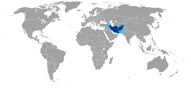
English: Map showing countries, autonomous subdivisions, and other regions where an Iranian language has official status and/or is spoken by a majority. Countries with an official Iranian language.
Autonomous subdivisions with an official Iranian language. Regions where an Iranian language is spoken by a majority. |
| Date | |
| Source | http://en.wikipedia.org/wiki/File:Map-TurkicLanguages.png |
| Author | Atilim Gunes Baydin |
| Permission (Reusing this file) |
http://en.wikipedia.org/wiki/File:Map-TurkicLanguages.png |
This file is licensed under the Creative Commons Attribution 1.0 Generic license.
- You are free:
- to share – to copy, distribute and transmit the work
- to remix – to adapt the work
- Under the following conditions:
- attribution – You must give appropriate credit, provide a link to the license, and indicate if changes were made. You may do so in any reasonable manner, but not in any way that suggests the licensor endorses you or your use.
Licensing
This file is licensed under the Creative Commons Attribution-Share Alike 3.0 Unported license.
- You are free:
- to share – to copy, distribute and transmit the work
- to remix – to adapt the work
- Under the following conditions:
- attribution – You must give appropriate credit, provide a link to the license, and indicate if changes were made. You may do so in any reasonable manner, but not in any way that suggests the licensor endorses you or your use.
- share alike – If you remix, transform, or build upon the material, you must distribute your contributions under the same or compatible license as the original.
File history
Click on a date/time to view the file as it appeared at that time.
| Date/Time | Thumbnail | Dimensions | User | Comment | |
|---|---|---|---|---|---|
| current | 12:06, 13 January 2023 | | 1,425 × 718 (62 KB) | LouisAragon | good faith edits; unexplained changes |
| 14:51, 5 January 2023 |  | 1,425 × 718 (42 KB) | Durranistan | . | |
| 14:45, 5 January 2023 |  | 1,425 × 718 (42 KB) | Durranistan | . | |
| 13:46, 8 September 2022 |  | 1,425 × 718 (62 KB) | Aintabli | Detailed Kurdish-speaking areas | |
| 15:27, 9 May 2019 |  | 1,425 × 625 (68 KB) | Akhemen | Correction Uzbekistan, Kyrgyzstan, Syria and UAE | |
| 22:37, 23 June 2018 |  | 1,425 × 625 (53 KB) | LouisAragon | Rv, utter unsourced nonsense. Iranian languages aren't spoken in India. | |
| 18:04, 18 April 2018 |  | 1,425 × 625 (64 KB) | Satoshi Kondo | map of another version of 2018, main change: iraq, iranian speaking population dobled in several regions | |
| 14:12, 1 March 2014 |  | 1,425 × 625 (53 KB) | HistoryofIran | . | |
| 14:13, 16 December 2013 |  | 1,425 × 625 (46 KB) | Mttll | Minor fix. | |
| 15:35, 7 June 2013 |  | 1,425 × 625 (53 KB) | HistoryofIran | {{subst:Upload marker added by en.wp UW}} {{Information |Description = {{en|Map showing countries and autonomous subdivisions where a Iranian language has official status and/or is spoken by a majority.}} |Source = http://en.wikipedia.org/wiki/File:Map... |
File usage
The following page uses this file:
Global file usage
The following other wikis use this file:
- Usage on af.wikipedia.org
- Usage on ar.wikipedia.org
- Usage on avk.wikipedia.org
- Usage on az.wikipedia.org
- Usage on be-tarask.wikipedia.org
- Usage on fa.wikipedia.org
- Usage on id.wikipedia.org
- Usage on is.wikipedia.org
- Usage on ku.wikipedia.org
- Usage on ml.wikipedia.org
- Usage on mr.wikipedia.org
- Usage on ms.wikipedia.org
- Usage on nl.wikipedia.org
- Usage on pa.wikipedia.org
- Usage on sco.wikipedia.org
- Usage on sl.wikipedia.org
- Usage on th.wikipedia.org
- Usage on tr.wikipedia.org
- Usage on vi.wikipedia.org
- Usage on zh-yue.wikipedia.org