
File:Map Trans-Siberian railway.png
Size of this preview: 800 × 566 pixels. Other resolutions: 320 × 226 pixels | 640 × 452 pixels | 1,000 × 707 pixels.
Original file (1,000 × 707 pixels, file size: 288 KB, MIME type: image/png)
| This is a file from the Wikimedia Commons. Information from its description page there is shown below. Commons is a freely licensed media file repository. You can help. |
Summary
| Description |
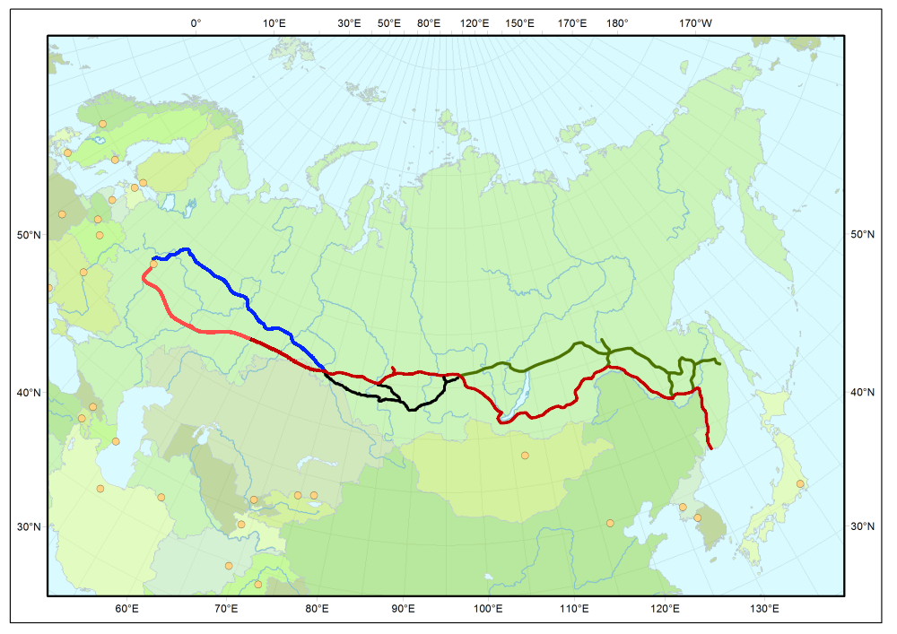
Map of Trans-Siberian railway
|
| Source | Own work |
| Author | User:Stefan Kühn |
| Permission (Reusing this file) |
Public domain |

|
Several vector versions of this file are available. These should be used in place of this PNG file. (reason:
English: Better quality and fix of errors. The new file is available without labels, with German labels and with labels in local language and English translation. Deutsch: Bessere Qualität und Fehlerbehebung. Die neue Datei ist ohne Beschriftung, mit deutschen Beschriftungen und mit Beschriftungen in Landessprache und englischer Übersetzung verfügbar. )File:Map Trans-Siberian railway.png →
For more information, see Help:SVG. |
   |
Licensing
| I, the copyright holder of this work, release this work into the public domain. This applies worldwide. In some countries this may not be legally possible; if so: I grant anyone the right to use this work for any purpose, without any conditions, unless such conditions are required by law. |
| Annotations | This image is annotated: View the annotations at Commons |
File history
Click on a date/time to view the file as it appeared at that time.
| Date/Time | Thumbnail | Dimensions | User | Comment | |
|---|---|---|---|---|---|
| current | 18:37, 5 August 2012 | | 1,000 × 707 (288 KB) | Miass | the real map of the Trans-Siberian railway line |
| 18:13, 5 August 2012 |  | 1,000 × 707 (289 KB) | Miass | the real map of the Trans-Siberian railway line | |
| 15:00, 26 January 2011 |  | 1,000 × 707 (321 KB) | Oschtan | Added the Southern branch line in Siberia, which, together with the historical path and the Baikal-Amur railway understudy Trans-Siberian Railway | |
| 17:48, 5 February 2009 |  | 1,000 × 707 (323 KB) | Chriusha | Historische Strecke zwischen Moskau und Omsk ergänzt. | |
| 08:49, 13 November 2005 |  | 1,000 × 707 (292 KB) | Stefan Kühn | Map of Trans-Siberian railway |
File usage
The following page uses this file:
Global file usage
The following other wikis use this file:
- Usage on af.wikipedia.org
- Usage on ar.wikipedia.org
- Usage on azb.wikipedia.org
- Usage on bg.wikipedia.org
- Usage on bn.wikipedia.org
- Usage on bs.wikipedia.org
- Usage on cu.wikipedia.org
- Usage on cv.wikipedia.org
- Usage on de.wikipedia.org
- Usage on de.wikivoyage.org
- Usage on de.wiktionary.org
- Usage on el.wikipedia.org
- Usage on el.wikivoyage.org
- Usage on en.wikipedia.org
- Chinese Eastern Railway
- Eurasian Land Bridge
- Portal:Trains/Did you know/May 2006
- User talk:Kelapstick/Archive 2
- Portal:Trains/Did you know/August 2008
- Wikipedia:Reference desk/Archives/Humanities/2012 July 3
- User:UBX/TransSiberian
- Ufa railway station
- User:HolyCrocsEmperor
- Wikipedia:Userboxes/Rail transport
- Usage on en.wikivoyage.org
- Usage on es.wikipedia.org
- Usage on et.wikipedia.org
- Usage on eu.wikipedia.org
- Usage on fa.wikipedia.org
- Usage on fi.wikipedia.org
- Usage on fr.wikipedia.org
- Usage on ga.wikipedia.org
- Usage on gl.wikipedia.org
- Usage on he.wikipedia.org
- Usage on hr.wikipedia.org
View more global usage of this file.