
File:Map of Franz Josef Land-en.svg

Size of this PNG preview of this SVG file: 800 × 535 pixels. Other resolutions: 320 × 214 pixels | 640 × 428 pixels | 1,024 × 685 pixels | 1,280 × 856 pixels | 2,560 × 1,712 pixels | 1,289 × 862 pixels.
Original file (SVG file, nominally 1,289 × 862 pixels, file size: 719 KB)
| This is a file from the Wikimedia Commons. Information from its description page there is shown below. Commons is a freely licensed media file repository. You can help. |
Summary
| Description |
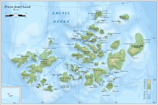
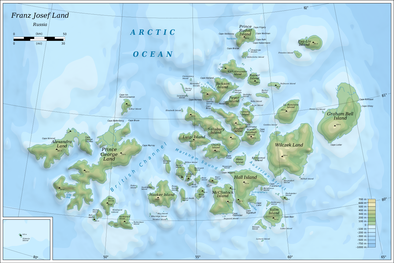
English: Map of Franz Josef Land of Russia. |
| Date | |
| Source |
Own work using: Inkscape.
|
| Author | Oona Räisänen |
| Other versions |
|
| SVG development |


Licensing
I, the copyright holder of this work, hereby publish it under the following licenses:
This file is licensed under the Creative Commons Attribution-Share Alike 3.0 Unported license.
- You are free:
- to share – to copy, distribute and transmit the work
- to remix – to adapt the work
- Under the following conditions:
- attribution – You must give appropriate credit, provide a link to the license, and indicate if changes were made. You may do so in any reasonable manner, but not in any way that suggests the licensor endorses you or your use.
- share alike – If you remix, transform, or build upon the material, you must distribute your contributions under the same or compatible license as the original.

|
Permission is granted to copy, distribute and/or modify this document under the terms of the GNU Free Documentation License, Version 1.2 or any later version published by the Free Software Foundation; with no Invariant Sections, no Front-Cover Texts, and no Back-Cover Texts. A copy of the license is included in the section entitled GNU Free Documentation License. |
You may select the license of your choice.
File history
Click on a date/time to view the file as it appeared at that time.
| Date/Time | Thumbnail | Dimensions | User | Comment | |
|---|---|---|---|---|---|
| current | 06:05, 12 August 2019 | | 1,289 × 862 (719 KB) | Cherkash | fixed some objects: names spelling, location |
| 14:24, 28 October 2010 |  | 1,289 × 862 (719 KB) | Mysid | shading + fixes | |
| 19:21, 26 October 2010 |  | 1,289 × 862 (719 KB) | Mysid | bigger fonts | |
| 19:13, 26 October 2010 |  | 1,289 × 862 (718 KB) | Mysid | {{Information |Description={{en|1=Map of en:Franz Josef Land of Russia.}} |Source={{own}}. Self-made in Inkscape. Topography and shoreline manually derived from a 1964 map by United States Army Map Service, Corps of Engineers ([[:File:NU-38-39-40-41 |
File usage
The following page uses this file:
Global file usage
The following other wikis use this file:
- Usage on af.wikipedia.org
- Usage on ar.wikipedia.org
- Usage on avk.wikipedia.org
- Wilczek (ewala)
- Teza:FranzJosefTursia
- Salm (ewala)
- Lütke (ewala)
- Hochstetter (ewala)
- Wilczek (ewalama)
- Schönau (ewala)
- Koldewey (ewala)
- Hall (ewala)
- Berghaus (ewala)
- McClintock (ewala)
- Heiss (ewala)
- Komsomol (ewala)
- Newcomb (ewala)
- Alger (ewala)
- Brice (ewala)
- Brady (ewala)
- Bliss (ewala)
- Nansen (ewala)
- Pritchett (ewala)
- Bromwich (ewala)
- Koettlitz (ewala)
- Hooker (ewala)
- Scott-Keltie (ewala)
- Royal Society (ewala)
- Leigh-Smith (ewala)
- Luigi (ewala)
- Salisbury (ewala)
- Champ (ewala)
- Ziegler (ewala)
- Wiener Neustadt (ewala)
- Franz-Josef (tursia)
- Greely (ewala)
- Kane (ewala)
- Kuhn (ewala)
- Payer (ewala)
- Jackson (ewala)
- Karl-Alexander (ewala)
- Rainer (ewala)
- Hohenlohe (ewala)
- Prince Rudolf (ewala)
- La Roncière (ewala)
- Becker (ewala)
- Hofmann (ewala)
- Freeden (ewala)
- Eva-Liv (ewala)
- Graham Bell (ewala)
- Bruce (ewala)
View more global usage of this file.