
File:Map of Manchester Metrolink.png

Size of this preview: 435 × 599 pixels. Other resolutions: 174 × 240 pixels | 348 × 480 pixels | 557 × 768 pixels | 743 × 1,024 pixels | 1,986 × 2,736 pixels.
Original file (1,986 × 2,736 pixels, file size: 4.1 MB, MIME type: image/png)
| This is a file from the Wikimedia Commons. Information from its description page there is shown below. Commons is a freely licensed media file repository. You can help. |
| Description |
|
|||
| Date | see file history | |||
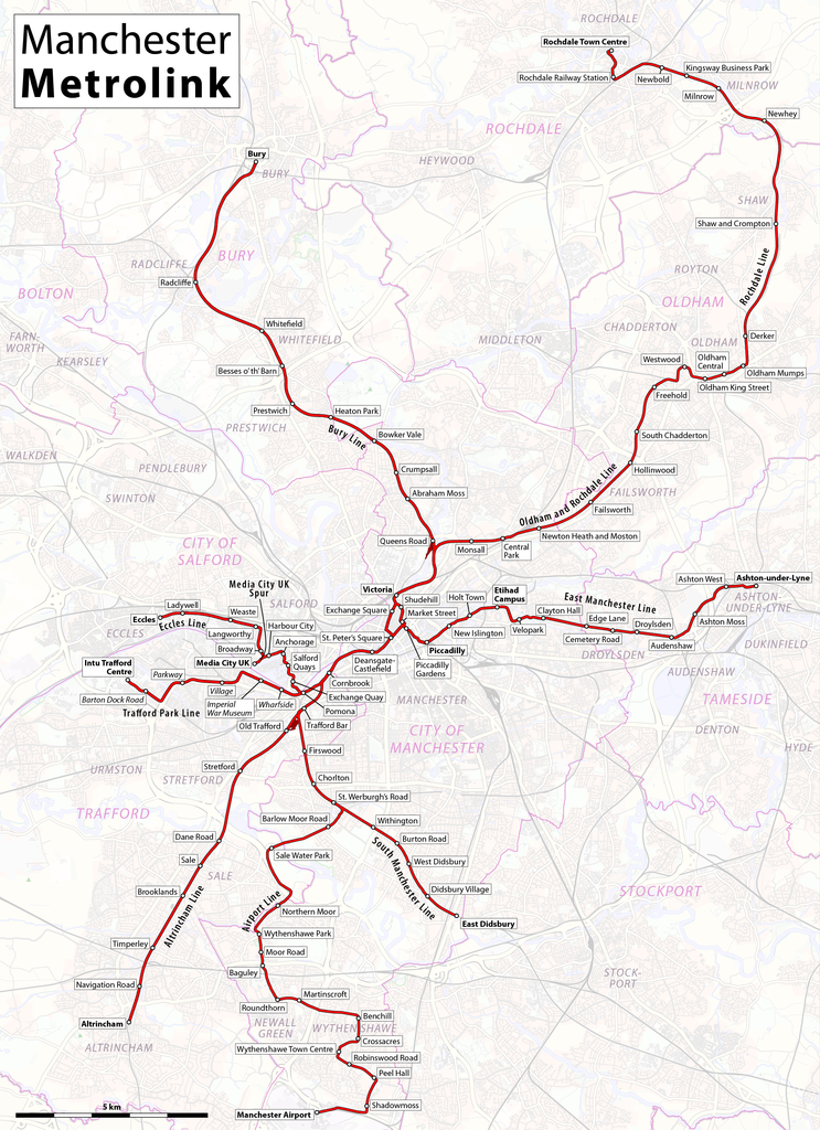
| Source | Own work, using OpenStreetMap data for the background | |||
| Author | Maximilian Dörrbecker (Chumwa) | |||
| Permission (Reusing this file) |
All OpenStreetMap data and maps are Creative Commons "CC-BY-SA 2.0" licensed This file is licensed under the Creative Commons Attribution-Share Alike 2.0 Generic license.
|
|||
| Other versions |
|


File history
Click on a date/time to view the file as it appeared at that time.
| Date/Time | Thumbnail | Dimensions | User | Comment | |
|---|---|---|---|---|---|
| current | 08:51, 13 June 2020 | | 1,986 × 2,736 (4.1 MB) | Chumwa | update |
| 23:18, 29 January 2018 |  | 1,986 × 2,736 (4.1 MB) | Chumwa | update | |
| 19:35, 18 March 2017 |  | 1,986 × 2,736 (4.1 MB) | Chumwa | ||
| 22:13, 1 March 2017 |  | 1,986 × 2,736 (4.09 MB) | Chumwa | update | |
| 22:45, 1 December 2016 |  | 1,986 × 2,736 (4.09 MB) | Chumwa | ||
| 07:44, 31 December 2015 |  | 1,986 × 2,736 (3.96 MB) | Chumwa | corr | |
| 03:08, 31 December 2015 |  | 1,986 × 2,736 (4.4 MB) | G-13114 | Correct spelling mistake of Piccadilly, edit out disused Moseley Street station, made clear that 2CC is not yet open | |
| 05:35, 24 August 2015 |  | 1,986 × 2,736 (3.96 MB) | Chumwa | ||
| 06:32, 11 August 2015 |  | 1,986 × 2,736 (3.9 MB) | Chumwa | ||
| 20:58, 10 August 2015 |  | 1,986 × 2,736 (3.61 MB) | Chumwa |
File usage
The following page uses this file:
Global file usage
The following other wikis use this file:
- Usage on cy.wikipedia.org
- Usage on de.wikipedia.org
- Usage on en.wikipedia.org
- Usage on eo.wikipedia.org
- Usage on es.wikipedia.org
- Usage on fi.wikipedia.org
- Usage on fr.wikipedia.org
- Usage on he.wikipedia.org
- Usage on id.wikipedia.org
- Usage on it.wikipedia.org
- Usage on ja.wikipedia.org
- Usage on ko.wikipedia.org
- Usage on nl.wikipedia.org
- Usage on nn.wikipedia.org
- Usage on no.wikipedia.org
- Usage on ru.wikipedia.org
- Usage on th.wikipedia.org
- Usage on tr.wikipedia.org
- Usage on uk.wikipedia.org
- Usage on www.wikidata.org
- Usage on zh.wikipedia.org