
File:Map of areas affected by 2021 European floods.svg

Size of this PNG preview of this SVG file: 587 × 600 pixels. Other resolutions: 235 × 240 pixels | 470 × 480 pixels | 752 × 768 pixels | 1,002 × 1,024 pixels | 2,004 × 2,048 pixels | 593 × 606 pixels.
Original file (SVG file, nominally 593 × 606 pixels, file size: 695 KB)
| This is a file from the Wikimedia Commons. Information from its description page there is shown below. Commons is a freely licensed media file repository. You can help. |
Summary
| Description |
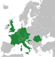
English: A map of the areas affected by the 2021 European Floods, derived from Blank map of Europe cropped.svg.
(Green) 2021 European floods.
(Gray) Europe.
(Light-gray) The surrounding region.
|
| Date | |
| Source | Own work |
| Author | Isochrone |
| Other versions |
This vector image includes elements that have been taken or adapted from this file: |
| SVG development |
Licensing
I, the copyright holder of this work, hereby publish it under the following license:
This file is licensed under the Creative Commons Attribution-Share Alike 4.0 International, 3.0 Unported, 2.5 Generic, 2.0 Generic and 1.0 Generic license.
- You are free:
- to share – to copy, distribute and transmit the work
- to remix – to adapt the work
- Under the following conditions:
- attribution – You must give appropriate credit, provide a link to the license, and indicate if changes were made. You may do so in any reasonable manner, but not in any way that suggests the licensor endorses you or your use.
- share alike – If you remix, transform, or build upon the material, you must distribute your contributions under the same or compatible license as the original.
File history
Click on a date/time to view the file as it appeared at that time.
| Date/Time | Thumbnail | Dimensions | User | Comment | |
|---|---|---|---|---|---|
| current | 10:01, 27 December 2022 | | 593 × 606 (695 KB) | Iktsokh | Correction of borders |
| 08:57, 22 July 2021 |  | 593 × 606 (692 KB) | Isochrone | update | |
| 14:12, 18 July 2021 |  | 593 × 606 (698 KB) | GPinkerton | Re-add France because there were also floods in France ([https://en.wikipedia.org/w/index.php?title=2021_European_floods&oldid=1034207380#France]). A more useful map would be by regions, there's no reason Sardinia, most of Great Britain, Northern Ireland, etc need to be here ... | |
| 09:44, 18 July 2021 |  | 593 × 606 (692 KB) | Jurryaany | Added Austria | |
| 18:28, 17 July 2021 |  | 593 × 606 (692 KB) | Isochrone | rm france | |
| 13:47, 17 July 2021 |  | 593 × 606 (692 KB) | Isochrone | better colour | |
| 13:40, 17 July 2021 |  | 593 × 606 (692 KB) | Isochrone | Uploaded own work with UploadWizard |
File usage
The following page uses this file:
Global file usage
The following other wikis use this file:
- Usage on fr.wikipedia.org
- Usage on ja.wikipedia.org
- Usage on ne.wikipedia.org
- Usage on pl.wikipedia.org
- Usage on pt.wikipedia.org
- Usage on ro.wikipedia.org
- Usage on tr.wikipedia.org