
File:Mappa Dialetti lombardi.svg

Size of this PNG preview of this SVG file: 800 × 592 pixels. Other resolutions: 320 × 237 pixels | 640 × 474 pixels | 1,024 × 758 pixels | 1,280 × 947 pixels | 2,560 × 1,895 pixels | 954 × 706 pixels.
Original file (SVG file, nominally 954 × 706 pixels, file size: 421 KB)
| This is a file from the Wikimedia Commons. Information from its description page there is shown below. Commons is a freely licensed media file repository. You can help. |
Summary
| Description |
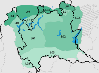
Italiano: Mappa dei Terriori di lingua lombarda; parlata principalmente in Lombardia, nella porzione orientale del Piemonte, oltre che nella Svizzera italiana e in parte del Trentino occidentale. |
| Date | |
| Source | Own work |
| Author | MacMoreno |
Licensing
I, the copyright holder of this work, hereby publish it under the following license:
This file is licensed under the Creative Commons Attribution-Share Alike 4.0 International license.
- You are free:
- to share – to copy, distribute and transmit the work
- to remix – to adapt the work
- Under the following conditions:
- attribution – You must give appropriate credit, provide a link to the license, and indicate if changes were made. You may do so in any reasonable manner, but not in any way that suggests the licensor endorses you or your use.
- share alike – If you remix, transform, or build upon the material, you must distribute your contributions under the same or compatible license as the original.
File history
Click on a date/time to view the file as it appeared at that time.
| Date/Time | Thumbnail | Dimensions | User | Comment | |
|---|---|---|---|---|---|
| current | 14:41, 8 December 2020 | | 954 × 706 (421 KB) | Stévan | Ho corretto un paio di problemi minori: il lago Maggiore risultava parzialmente invisibile, perché coperto da un layer; mancava infine la divisione dialettale del Canton Ticino (tra Sottoceneri e Sopraceneri), già indicata nell'immagine madre, nonché nel contenuto e nelle fonti delle voci in cui è usata l'immagine. |
| 09:00, 3 April 2019 |  | 954 × 706 (354 KB) | MacMoreno | Ritocco confini adiacenti alla Lombardia | |
| 18:56, 2 April 2019 |  | 954 × 706 (354 KB) | MacMoreno | Aggiornamento Mappa | |
| 12:31, 2 April 2019 |  | 808 × 695 (248 KB) | MacMoreno | User created page with UploadWizard |
File usage
The following page uses this file:
Global file usage
The following other wikis use this file:
- Usage on bg.wikipedia.org
- Usage on ca.wikipedia.org
- Usage on eml.wikipedia.org
- Usage on en.wikipedia.org
- Usage on fr.wikipedia.org
- Usage on gl.wikipedia.org
- Usage on it.wikipedia.org
- Lugano
- Dialetto bergamasco
- Poesia dialettale milanese
- Gaì
- Dialetto milanese
- Capitan Slaff
- Dialetto comasco
- L'albero degli zoccoli
- Dialetto cremonese
- Dialetto brianzolo
- Dialetto lecchese
- Dialetto bresciano
- Dialetto novarese
- Dialetto cremasco
- Stramilano (brano musicale)
- Bosinada
- Dialetto bustocco
- Dialetto mantovano
- Ortografia milanese classica
- Dialetto ticinese
- Letteratura milanese
- Milanese - Antologia della canzone lombarda
- Spasell
- L'Ambleto
- Dialetto pavese
- Dialetto legnanese
- Lingua lombarda
- Dialetto chiavennasco
- Varon Milanes
View more global usage of this file.