
File:Michigan Lower Peninsula Regions.png
No higher resolution available.
Michigan_Lower_Peninsula_Regions.png (292 × 278 pixels, file size: 30 KB, MIME type: image/png)
| This is a file from the Wikimedia Commons. Information from its description page there is shown below. Commons is a freely licensed media file repository. You can help. |
Summary
| Description |
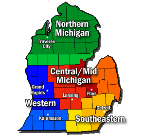
English: The four major geographical and economical regions of the Lower Peninsula of State of Michigan. Includes: Northern Michigan (Greens), Mid-Michigan (Reds and oranges), Western Michigan (Blues), and Southeast Michigan (Yellows). Generally accepted principal regions are shaded dark, while overlapping areas and sub-regions are shaded lightly. PLEASE NOTE All regions and boundaries are relative. This a compilation of many different region maps, including [1] and [2] |
| Date | |
| Source | Own work |
| Author | Mac1island |
![[1]](https://en.wikipedia.org/wiki/File:Lower_Michigan_Region_Map.png)
![[2]](https://en.wikipedia.org/wiki/File:Michigan_Regions.svg)
Licensing
I, the copyright holder of this work, hereby publish it under the following license:
This file is licensed under the Creative Commons Attribution-Share Alike 3.0 Unported license.
- You are free:
- to share – to copy, distribute and transmit the work
- to remix – to adapt the work
- Under the following conditions:
- attribution – You must give appropriate credit, provide a link to the license, and indicate if changes were made. You may do so in any reasonable manner, but not in any way that suggests the licensor endorses you or your use.
- share alike – If you remix, transform, or build upon the material, you must distribute your contributions under the same or compatible license as the original.
File history
Click on a date/time to view the file as it appeared at that time.
| Date/Time | Thumbnail | Dimensions | User | Comment | |
|---|---|---|---|---|---|
| current | 00:56, 14 February 2012 | | 292 × 278 (30 KB) | Mac1island | Added "Michigan" to "Central/Mid" |
| 00:27, 14 February 2012 |  | 292 × 278 (29 KB) | Mac1island | Central/Mid Michigan are synonymous terms. | |
| 22:33, 21 November 2011 |  | 292 × 278 (28 KB) | Mac1island | Please note changes in shading. After discussion and further research, the Central Michigan area (orange) is expanded. Separate shading was done for the southern Michigan area around Kalamazoo (light blue) and also around Jackson (light yellow) | |
| 20:45, 20 November 2011 |  | 292 × 278 (29 KB) | Mac1island | Added Kalamazoo to the area of Southern Michigan. Outlined city text. | |
| 18:22, 20 November 2011 |  | 292 × 278 (29 KB) | Mac1island | A simplified and modified version based on five principle regions and their subsuquent overlapping sub-regions. All boundaries are relative. Principal regions are dark shaded, while overlapping regions are lightly shaded. | |
| 23:16, 19 November 2011 |  | 507 × 474 (76 KB) | Mac1island |
File usage
The following page uses this file:
Global file usage
The following other wikis use this file:
- Usage on bn.wikipedia.org
- Usage on de.wikipedia.org
- Usage on en.wikipedia.org
- Usage on nl.wikipedia.org
- Usage on zh.wikipedia.org