
File:Mount Rainier 7437.JPG
Size of this preview: 800 × 600 pixels. Other resolutions: 320 × 240 pixels | 640 × 480 pixels | 1,024 × 768 pixels | 1,280 × 960 pixels | 1,600 × 1,200 pixels.
Original file (1,600 × 1,200 pixels, file size: 559 KB, MIME type: image/jpeg)
| This is a file from the Wikimedia Commons. Information from its description page there is shown below. Commons is a freely licensed media file repository. You can help. |
Summary
| Description |
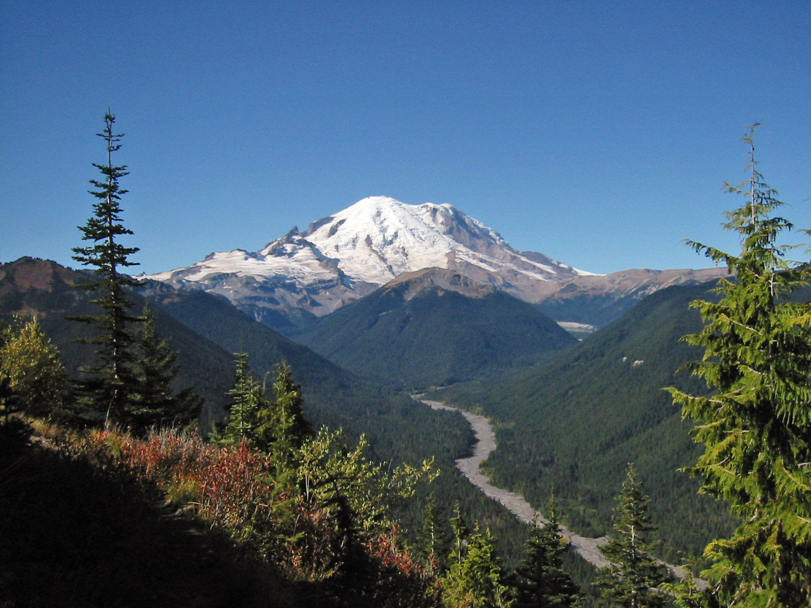
English: Mount Rainier with its main summit, Columbia Crest (14410 feet) at the center. Liberty Cap (14112 feet) is to the right behind Russell Cliff. Curtis Ridge descends to the right from Russell Cliff. Massive Emmons Glacier covers most of the visible flank of the mountain. Winthrop Glacier flows right along Curtis Ridge and behind shallow Steamboat Prow (9680 feet) with the small Inter Glacier on its northeast face. Ingraham Glacier (left) is between Gibralter Rock (12660 feet) high on the left skyline and Disappointment Cleaver. Left of Gibralter Rock is sharp pointed Little Tahoma (11138 feet) with Frying Pan Glacier on its flank. It is the source of Frying Pan Creek in the valley left of forested and rounded Goat Island Mountain, in front of the Emmons Glacier. It flows into the White River which comes from the Emmons Glacier and flows around the right side of Goat Island Mountain. In the middle distance, the White River Valley is bounded by Governors Ridge (left) and Sunrise Ridge (right). In the foregroun d is a Subalpine Fir (left) and a Yellow Cedar (right). |
| Date | 25 September 2005, 11:35:12 −07:00 |
| Source | Own work |
| Author | Walter Siegmund (talk) |
| Camera location | | View this and other nearby images on: OpenStreetMap |
|---|
- Location Datum: WGS84/NAD83
- Viewpoint location: Crystal Peak Trail, Mount Rainier National Park
- Viewpoint elevation: 5500 foot (1676 m)
- View direction: West-southwest
- Camera: Canon Canon PowerShot S110
- Exposure Time: 1/640
- F Number: f/7.2
- Focal Length: 5.4
- Focal Length In 35mm Film:
- Flash: No
- ISO Speed Rating:
©2006 Walter Siegmund
Licensing
I, the copyright holder of this work, hereby publish it under the following licenses:

|
Permission is granted to copy, distribute and/or modify this document under the terms of the GNU Free Documentation License, Version 1.2 or any later version published by the Free Software Foundation; with no Invariant Sections, no Front-Cover Texts, and no Back-Cover Texts. A copy of the license is included in the section entitled GNU Free Documentation License. |
| This file is licensed under the Creative Commons Attribution-Share Alike 3.0 Unported license. | ||
| ||
| This licensing tag was added to this file as part of the GFDL licensing update. |
This file is licensed under the Creative Commons Attribution 2.5 Generic license.
- You are free:
- to share – to copy, distribute and transmit the work
- to remix – to adapt the work
- Under the following conditions:
- attribution – You must give appropriate credit, provide a link to the license, and indicate if changes were made. You may do so in any reasonable manner, but not in any way that suggests the licensor endorses you or your use.
You may select the license of your choice.
File history
Click on a date/time to view the file as it appeared at that time.
| Date/Time | Thumbnail | Dimensions | User | Comment | |
|---|---|---|---|---|---|
| current | 21:37, 9 April 2008 | | 1,600 × 1,200 (559 KB) | Wsiegmund | Photoshop Elements Autosmartfix and Autocolorcorrection tools |
| 18:16, 5 March 2006 |  | 1,600 × 1,200 (343 KB) | Wsiegmund | ||
| 03:51, 13 February 2006 |  | 1,600 × 1,200 (468 KB) | Wsiegmund | '''Mount Rainier''' * '''Description:''' Mount Rainier with its main summit, Columbia Crest (14410 feet) at the center. Liberty Cap (14112 feet) is to the right behind Russell Cliff. Curtis Ridge descends to the right from Russell Cliff. Massive Emmons Gl |
File usage
There are no pages that use this file.
Global file usage
The following other wikis use this file:
- Usage on ar.wikipedia.org
- Usage on ca.wikipedia.org
- Usage on de.wikipedia.org
- Usage on en.wikipedia.org
- Usage on eo.wikipedia.org
- Usage on es.wikipedia.org
- Usage on fi.wikipedia.org
- Usage on fi.wikiversity.org
- Usage on fr.wikipedia.org
- Liste des parcs nationaux des États-Unis
- Parc national du mont Rainier
- Wikipédia:Sélection/Conservation de la nature
- Wikipédia:Sélection/Architecture et Urbanisme
- Wikipédia:Sélection/Amérique
- Wikipédia:Sélection/Washington (État)
- Forêts du centre et du sud de la chaîne des Cascades
- Wikipédia:Lumière sur/Août 2010
- Wikipédia:Lumière sur/Parc national du mont Rainier
- Wikipédia:Sélection/États-Unis/Articles de qualité
- Wikipédia:Sélection/Registre national des lieux historiques
- Eliza Ruhamah Scidmore
- Usage on fy.wikipedia.org
- Usage on he.wikipedia.org
- Usage on he.wikivoyage.org
- Usage on hu.wikipedia.org
- Usage on it.wikipedia.org
- Usage on oc.wikipedia.org
- Usage on ru.wikipedia.org
- Usage on sco.wikipedia.org
- Usage on sr.wikipedia.org
- Usage on tr.wikipedia.org
- Usage on www.wikidata.org