
File:Point Arena Lighthouse.jpg

Size of this preview: 432 × 599 pixels. Other resolutions: 173 × 240 pixels | 346 × 480 pixels | 553 × 768 pixels | 738 × 1,024 pixels | 2,139 × 2,968 pixels.
Original file (2,139 × 2,968 pixels, file size: 2.8 MB, MIME type: image/jpeg)
| This is a file from the Wikimedia Commons. Information from its description page there is shown below. Commons is a freely licensed media file repository. You can help. |
Summary
| Camera location | | View this and other nearby images on: OpenStreetMap |
|---|
| Description |
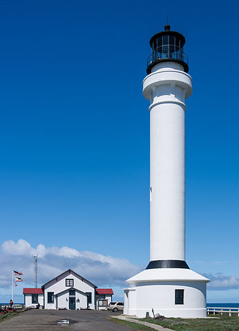
English: Point Arena Lighthouse, Mendocino County, California. Deutsch: Point Arena Leuchtturm, Mendocino County, Kalifornien. |
| Date | |
| Source | Own work |
| Author | Frank Schulenburg |
| Other versions | File:Point Arena Lighthouse (March 2012).jpg (corrected version) |
.jpg)
|
This is an image of a place or building that is listed on the National Register of Historic Places in the United States of America. Its reference number is 90002189. |
Licensing
I, the copyright holder of this work, hereby publish it under the following license:
This file is licensed under the Creative Commons Attribution-Share Alike 3.0 Unported license.
- You are free:
- to share – to copy, distribute and transmit the work
- to remix – to adapt the work
- Under the following conditions:
- attribution – You must give appropriate credit, provide a link to the license, and indicate if changes were made. You may do so in any reasonable manner, but not in any way that suggests the licensor endorses you or your use.
- share alike – If you remix, transform, or build upon the material, you must distribute your contributions under the same or compatible license as the original.
This image has been assessed using the Quality image guidelines and is considered a Quality image.
|
File history
Click on a date/time to view the file as it appeared at that time.
| Date/Time | Thumbnail | Dimensions | User | Comment | |
|---|---|---|---|---|---|
| current | 10:18, 7 April 2012 | | 2,139 × 2,968 (2.8 MB) | Carschten | straightened |
| 23:56, 25 March 2012 |  | 2,358 × 3,092 (3.14 MB) | Frank Schulenburg |
File usage
The following page uses this file:
Global file usage
The following other wikis use this file:
- Usage on ar.wikipedia.org
- Usage on arz.wikipedia.org
- Usage on bg.wikipedia.org
- Usage on ca.wikipedia.org
- Usage on ceb.wikipedia.org
- Usage on ce.wikipedia.org
- Usage on de.wikipedia.org
- Usage on en.wikipedia.org
- Mendocino County, California
- Point Arena Light
- Wikipedia:Featured picture candidates/Point Arena Lighthouse
- Wikipedia:Featured picture candidates/July-2012
- California Historical Landmarks in Mendocino County
- List of lighthouses in California
- Wikipedia:Featured picture candidates/September-2022
- Wikipedia:Featured picture candidates/Point Arena Light
- Usage on en.wikivoyage.org
- Usage on eu.wikipedia.org
- Usage on fr.wikipedia.org
- Usage on ht.wikipedia.org
- Usage on it.wikipedia.org
- Usage on lld.wikipedia.org
- Usage on ml.wikipedia.org
- Usage on no.wikipedia.org
- Usage on pl.wikipedia.org
- Usage on ru.wikipedia.org
- Usage on sr.wikipedia.org
- Usage on tt.wikipedia.org
- Usage on ur.wikipedia.org
- Usage on uz.wikipedia.org
- Usage on vi.wikipedia.org
- Usage on www.wikidata.org
- Usage on zh-min-nan.wikipedia.org
- Usage on zh-yue.wikipedia.org
- Usage on zh.wikipedia.org