
File:Sambreville Namur Belgium Map.png
No higher resolution available.
Sambreville_Namur_Belgium_Map.png (230 × 275 pixels, file size: 4 KB, MIME type: image/png)
| This is a file from the Wikimedia Commons. Information from its description page there is shown below. Commons is a freely licensed media file repository. You can help. |
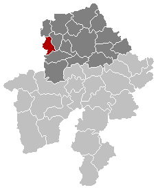
Map, municipality belgium Sambreville
| This work has been released into the public domain by its author, LennartBolks. This applies worldwide. In some countries this may not be legally possible; if so: |
FR; Carte indiquant la localisation de la commune de Sambreville dans la Province de Namur.
EN; Map from w:nl:Gebruiker:LennartBolks/kaartenhoekje in Public Domain by the Author choice.
File history
Click on a date/time to view the file as it appeared at that time.
| Date/Time | Thumbnail | Dimensions | User | Comment | |
|---|---|---|---|---|---|
| current | 17:08, 27 November 2005 | | 230 × 275 (4 KB) | Srtxg | arr. in dark |
| 20:45, 23 February 2005 |  | 230 × 275 (4 KB) | Nicnac25~commonswiki | Map, municipality belgium Sambreville |
File usage
There are no pages that use this file.
Global file usage
The following other wikis use this file:
- Usage on br.wikipedia.org
- Usage on eo.wikipedia.org
- Usage on es.wikipedia.org
- Usage on fa.wikipedia.org
- Usage on it.wikipedia.org
- Usage on li.wikipedia.org
- Usage on pt.wikipedia.org
- Usage on ro.wikipedia.org
- Usage on ru.wikipedia.org
- Usage on sk.wikipedia.org
- Usage on sv.wikipedia.org
- Usage on vi.wikipedia.org