
File:Sudbury Wanapitei WorldWind.jpg

Size of this preview: 800 × 600 pixels. Other resolutions: 320 × 240 pixels | 640 × 480 pixels | 1,024 × 768 pixels.
Original file (1,024 × 768 pixels, file size: 308 KB, MIME type: image/jpeg)
| This is a file from the Wikimedia Commons. Information from its description page there is shown below. Commons is a freely licensed media file repository. You can help. |
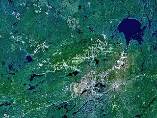
| Description | The Sudbury and Wanapitei impact craters in Ontario, Canada. Sudbury is the large, elliptical structure (60 x 30 km); Wanapitei is the lake filled crater at upper right. Its diameter is 8km, its age 37 million years. |
| Source | Created with NASA WorldWind by User:Vesta using Landsat 7 (Visible Color) satellite image. |
| Author | User:Vesta |
46°36′0″N 81°11′0″W / 46.6°N 81.18333°W
| This image is in the public domain because it is a screenshot from NASA’s globe software World Wind using a public domain layer, such as Blue Marble, MODIS, Landsat, SRTM, USGS or GLOBE.
|
 |
File history
Click on a date/time to view the file as it appeared at that time.
| Date/Time | Thumbnail | Dimensions | User | Comment | |
|---|---|---|---|---|---|
| current | 09:52, 7 January 2006 | | 1,024 × 768 (308 KB) | Vesta~commonswiki | * '''Description:''' The Sudbury and Wanapitei impact craters in Ontario, Canada. Sudbury is the large, elliptical structure (60 x 30 km), Wanapitei is the lake filled crater at upper right. *'''Source:''' Created with NASA WorldWind by User:Vesta usi |
File usage
The following page uses this file:
Global file usage
The following other wikis use this file:
- Usage on af.wikipedia.org
- Usage on ar.wikipedia.org
- Usage on ca.wikipedia.org
- Usage on ceb.wikipedia.org
- Usage on cs.wikipedia.org
- Usage on de.wikipedia.org
- Usage on en.wikipedia.org
- Usage on es.wikipedia.org
- Usage on eu.wikipedia.org
- Usage on fa.wikipedia.org
- Usage on fr.wikipedia.org
- Usage on he.wikipedia.org
- Usage on hu.wikipedia.org
- Usage on id.wikipedia.org
- Usage on it.wikipedia.org
- Usage on ja.wikipedia.org
- Usage on kw.wikipedia.org
- Usage on nl.wikipedia.org
- Usage on ro.wikipedia.org
- Usage on ru.wikipedia.org
- Usage on sk.wikipedia.org
- Usage on tr.wikipedia.org
- Usage on uk.wikipedia.org
- Usage on uz.wikipedia.org
- Usage on vi.wikipedia.org
- Usage on www.wikidata.org
- Usage on zh.wikipedia.org