
File:Volcanic system of Iceland-Map-en.svg

Size of this PNG preview of this SVG file: 726 × 588 pixels. Other resolutions: 296 × 240 pixels | 593 × 480 pixels | 948 × 768 pixels | 1,264 × 1,024 pixels | 2,529 × 2,048 pixels.
Original file (SVG file, nominally 726 × 588 pixels, file size: 345 KB)
| This is a file from the Wikimedia Commons. Information from its description page there is shown below. Commons is a freely licensed media file repository. You can help. |
| Description |
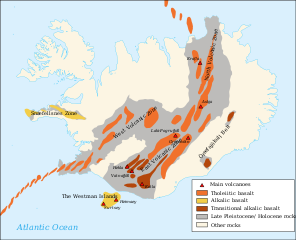
Français : Carte en anglais du système volcanique de l'Islande English: Map in English of the volcanic system of Iceland
Íslenska: Gosbelti Íslands.
A similar but different image that may have informed part of the original image that was created in 2008 is in Sveinn P. Jakobsson, Kristján Jónasson og Ingvar A. Sigurðsson 2008. The three igneous rock series of Iceland. Jökull 58: 117–138. |
| Date | (UTC) |
| Source | |
| Author |
|
| Other versions |
Derivative works of this file: |
| This is a retouched picture, which means that it has been digitally altered from its original version. Modifications: English translation. The original can be viewed here: Volcanic system of Iceland-Map-fr.svg:
|
I, the copyright holder of this work, hereby publish it under the following licenses:
This file is licensed under the Creative Commons Attribution-Share Alike 3.0 Unported, 2.5 Generic, 2.0 Generic and 1.0 Generic license.
- You are free:
- to share – to copy, distribute and transmit the work
- to remix – to adapt the work
- Under the following conditions:
- attribution – You must give appropriate credit, provide a link to the license, and indicate if changes were made. You may do so in any reasonable manner, but not in any way that suggests the licensor endorses you or your use.
- share alike – If you remix, transform, or build upon the material, you must distribute your contributions under the same or compatible license as the original.

|
Permission is granted to copy, distribute and/or modify this document under the terms of the GNU Free Documentation License, Version 1.2 or any later version published by the Free Software Foundation; with no Invariant Sections, no Front-Cover Texts, and no Back-Cover Texts. A copy of the license is included in the section entitled GNU Free Documentation License. |
You may select the license of your choice.
Original upload log
This image is a derivative work of the following images:
- File:Volcanic_system_of_Iceland-Map-fr.svg licensed with Cc-by-sa-3.0,2.5,2.0,1.0, GFDL
- 2008-03-05T17:48:55Z Pinpin 726x588 (370851 Bytes) '
- 2008-03-04T17:56:34Z Pinpin 726x588 (370488 Bytes) '
- 2008-03-04T17:51:23Z Pinpin 726x588 (369885 Bytes) +volcanoes
- 2008-03-03T10:42:50Z Pinpin 726x588 (356747 Bytes) {{Information |Description={{fr|Carte en français du système volcanique de l'Islande}} {{en|Map in french of the volcanic system of Iceland}} |Source=Own work made with inkscape from [[:Image:Blank map of Iceland.svg]] and
Uploaded with derivativeFX
| Annotations | This image is annotated: View the annotations at Commons |
File history
Click on a date/time to view the file as it appeared at that time.
| Date/Time | Thumbnail | Dimensions | User | Comment | |
|---|---|---|---|---|---|
| current | 15:39, 4 August 2019 | | 726 × 588 (345 KB) | Rohieb | translate "Snæfellsnes Zone" after the original french version is now translatable |
| 13:44, 18 April 2010 |  | 726 × 588 (362 KB) | Chris.urs-o | Typo, volcano to volcanoes, high alumina basalt to transitional alkalic basalt | |
| 20:49, 30 March 2010 |  | 726 × 588 (362 KB) | Chris.urs-o | {{Information |Description={{fr|Carte en français du système volcanique de l'Islande}} {{en|Map in french of the volcanic system of Iceland}} |Source=*File:Volcanic_system_of_Iceland-Map-fr.svg |Date=2010-03-30 20:48 (UTC) |Author=*[[:File:Volcani |
File usage
The following page uses this file:
Global file usage
The following other wikis use this file:
- Usage on ar.wikipedia.org
- Usage on ca.wikipedia.org
- Usage on cs.wikipedia.org
- Usage on da.wikipedia.org
- Usage on de.wikipedia.org
- Usage on en.wikipedia.org
- Geography of Iceland
- Hekla
- Volcanism of Iceland
- Eyjafjallajökull
- Iceland hotspot
- List of Quaternary volcanic eruptions
- Category:Öræfajökull Belt
- Category:Snæfellsnes
- Brennisteinsfjöll
- User:Avenue/sandbox
- User:Chienlit/sandbox
- Geological deformation of Iceland
- User:GeekyEnki/sandbox/Eyjafjallajökull
- Category:Volcanic systems of Iceland
- Krýsuvík (volcanic system)
- Category:North Volcanic Zone of Iceland
- Category:West Volcanic Zone of Iceland
- List of volcanic eruptions in Iceland
- Usage on es.wikipedia.org
- Usage on fi.wikipedia.org
- Usage on fr.wikipedia.org
- Usage on it.wikipedia.org
- Usage on ja.wikipedia.org
- Usage on ka.wikipedia.org
- Usage on lb.wikipedia.org
- Usage on li.wikipedia.org
- Usage on mk.wikipedia.org
- Usage on no.wikipedia.org
- Usage on pt.wikipedia.org
- Usage on sr.wikipedia.org
- Usage on su.wikipedia.org
- Usage on sv.wikipedia.org
- Usage on ta.wikipedia.org
- Usage on tr.wikipedia.org
- Usage on uk.wikipedia.org
- Usage on xmf.wikipedia.org
- Usage on zh.wikipedia.org