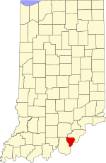
Floyd County, Indiana
Floyd County | |
|---|---|
 Floyd County, Indiana | |
 Location within the U.S. state of Indiana | |
 Indiana's location within the U.S. | |
| Coordinates: 38°19′N 85°54′W / 38.32°N 85.9°W | |
| Country | |
| State | |
| Founded | 1819 |
| Named for | Brigadier General John Floyd |
| Seat | New Albany |
| Largest city | New Albany |
| Area | |
| • Total | 148.96 sq mi (385.8 km2) |
| • Land | 147.94 sq mi (383.2 km2) |
| • Water | 1.02 sq mi (2.6 km2) 0.68% |
| Population | |
| • Total | 80,484 |
| • Density | 504/sq mi (194.57/km2) |
| Time zone | UTC−5 (Eastern) |
| • Summer (DST) | UTC−4 (EDT) |
| Congressional district | 9th |
| Website | www |
$3
| |
Floyd County is a county in the U.S. state of Indiana. As of 2020, 80,484 people lived there.[1] The county seat is New Albany.[2] It is the second smallest county in Indiana by area. It was created in 1819.
References[change | change source]
- ↑ 1.0 1.1 "QuickFacts: Floyd County, Indiana". United States Census Bureau. Retrieved September 25, 2023.
- ↑ "Find a County". National Association of Counties. Archived from the original on 2011-05-31. Retrieved 2011-06-07.
