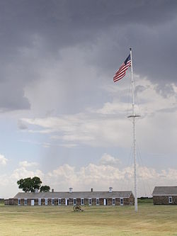
Fort Larned National Historic Site
Fort Larned National Historic Site | |
 Fort Larned Flagpole and Commissary Building | |
| Location | Pawnee County, Kansas, Kansas route 156, USA |
|---|---|
| Nearest city | Larned, Kansas |
| Coordinates | 38°10′59″N 99°13′05″W / 38.18306°N 99.21806°W |
| Area | 718 acres (2.91 km²) |
| Built | 1860 |
| Architect | Quartermaster Dept., U.S. Army |
| Visitation | 31,551 (2005) |
| NRHP reference No. | 66000107[1] |
| Significant dates | |
| Added to NRHP | October 15, 1966 |
| Designated NHS | August 31, 1964 |
Fort Larned National Historic Site is a place that preserves Fort Larned. Fort Larned was a fort that was used from 1859 to 1878. It is about 5.5 miles (8.9 km) west of Larned, Kansas, United States.
History[change | change source]
The Camp on Pawnee Fork was built on October 22, 1859. it was created to protect people along the Santa Fe Trail from angry American Indians.[2]
References[change | change source]
- ↑ "National Register Information System". National Register of Historic Places. National Park Service. 2009-03-13.
- ↑ "History and Culture". National Park Service. Retrieved 2013-12-16.
Other websites[change | change source]
Wikimedia Commons has media related to Fort Larned National Historic Site.
- Official Websites
- National Park Service: Fort Larned National Historic Site
- Santa Fe Trail Center, museum devoted to the history of the Santa Fe Trail in city of Larned
- Articles
- The Story of Fort Larned, 1957 article, Kansas Historical Quarterly
- Fort Larned celebrates 50th anniversary as national park site, 2014 article, The Wichita Eagle
- Extensive photos of Fort Larned, kansastravel.org
- National Register of Historic Places
- Historic American Buildings Survey
- Historic American Buildings Survey (HABS) No. KS-21, "Fort Larned, Barracks (West), Larned, Pawnee County, KS", 12 photos, 5 measured drawings
- HABS No. KS-22, "Fort Larned, Barracks (East), Larned, Pawnee County, KS", 8 photos, 5 measured drawings
- HABS No. KS-23, "Fort Larned, Blacksmith & Wheelwright Shop, Larned, Pawnee County, KS", 6 photos, 4 measured drawings
- HABS No. KS-24, "Fort Larned, Bakery & Mess Hall, Larned, Pawnee County, KS", 5 photos, 4 measured drawings
- HABS No. KS-25, "Fort Larned, Commissary Storehouse & Stables, Larned, Pawnee County, KS", 8 photos, 4 measured drawings
- HABS No. KS-26, "Fort Larned, Quartermaster Storehouse, Larned, Pawnee County, KS", 6 photos, 7 measured drawings
- HABS No. KS-27, "Fort Larned, Officers' Quarters (South), Larned, Pawnee County, KS", 11 photos, 6 measured drawings
- HABS No. KS-28, "Fort Larned, Commanding Officer Quarters, Larned, Pawnee County, KS", 6 photos, 7 measured drawings
- HABS No. KS-29, "Fort Larned, Officers' Quarters (North), Larned, Pawnee County, KS", 3 photos, 6 measured drawings
- County Maps


