
Garajonay National Park
| Garajonay National Park | |
|---|---|
IUCN category II (national park) | |
 | |
| Location | La Gomera, Canary Islands, Spain |
| Coordinates | 28°07′34″N 17°14′14″W / 28.12611°N 17.23722°W |
| Area | 40 km2 (15 sq mi) |
| Established | 1981 |
| Type | Natural |
| Criteria | vii, ix |
| Designated | 1986 (10th session) |
| Reference no. | 380 |
| State Party | |
| Region | Europe and North America |
Garajonay National Park (Spanish: Parque nacional de Garajonay) is one of the national parks of Spain. It is in the center and north of the island of La Gomera which is one of the Canary Islands off the coast of Morocco.
It is named for Alto de Garajonay which is the highest peak on the island.[1] The park is usually covered by clouds which helps preserve over 150 species of plants.[2] Garajonay became a national park in 1981.[2] It was declared as World Heritage Site by UNESCO in 1986.[2] It occupies 40 km2 (15 sq mi) and it extends into each of the six municipalities on the island.
Gallery[change | change source]
-
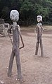 The park's wooden statues of Gara and Jonay
 -
 Garajonay National Park seen by Spot Satellite
 -
 Enchanted Forest, Garajonay National Park, La Gomera, Spain.
 -
 Guanche Sanctuary in the summit of Garajonay mountain.
 -
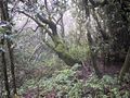 Laurisilva in the Garajonay National Park.


References[change | change source]
Other websites[change | change source]
Wikimedia Commons has media related to Parque nacional de Garajonay.
- Garajonay National Park Archived 2014-09-11 at the Wayback Machine
- (in Spanish) Legend of Gara and Jonay Archived 2004-12-28 at the Wayback Machine
| International | |
|---|---|
| National | |