
Gas, Kansas
Gas, Kansas | |
|---|---|
 "Gas Kan"- shaped Watertower in Gas (2012) | |
| Motto(s): "Don't Pass Gas, Stop and Enjoy It"[1] | |
 Location within Allen County and Kansas | |
 | |
| Coordinates: 37°55′21″N 95°20′41″W / 37.92250°N 95.34472°W[2] | |
| Country | United States |
| State | Kansas |
| County | Allen |
| Township | Elm |
| Founded | 1898 |
| Incorporated | 1901 |
| Named for | Natural gas |
| Area | |
| • Total | 0.72 sq mi (1.87 km2) |
| • Land | 0.72 sq mi (1.86 km2) |
| • Water | 0.00 sq mi (0.00 km2) |
| Elevation | 1,020 ft (310 m) |
| Population | |
| • Total | 475 |
| • Density | 660/sq mi (250/km2) |
| Time zone | UTC-6 (CST) |
| • Summer (DST) | UTC-5 (CDT) |
| ZIP code | 66742 |
| Area code | 620 |
| FIPS code | 20-25975 |
| GNIS ID | 2394865[2] |
| Website | cityofgas.com |
Gas is a city in the northwestern part of Allen County, in southeast Kansas, in the Central United States. In 2020, 475 people lived there.[4] The city was named for the natural gas that was found in the area.[5]
History[change | change source]
In the summer of 1898 in Elm Township, E.K. Taylor sold 60 acres (24 ha) of his farm to some spelter companies when natural gas was found in the area. This was the beginning of "Gas City". The place grew quickly. In 1910 the population was 1,281, and the city had a bank, a daily and a weekly newspaper, an opera house, an international money order postoffice (first opened in August 1899[6]).[7]
Geography[change | change source]
Gas is at 37°55′21″N 95°20′41″W / 37.92250°N 95.34472°W (37.92257, -95.344956).[3] It is along U.S. Route 54 in Elm Township. Gas is about three miles (5 km) east of Iola (the county seat) and 2½ miles west of the city of La Harpe. The interchange between U.S. Routes 54 and 169 is about two miles (3 km) west of Gas.
The United States Census Bureau says that the city has a total area of 0.72 square miles (1.86 km2). All of it is land.[3]
People[change | change source]
| Historical population | |||
|---|---|---|---|
| Census | Pop. | %± | |
| 1910 | 1,281 | — | |
| 1920 | 367 | −71.4% | |
| 1930 | 326 | −11.2% | |
| 1940 | 357 | 9.5% | |
| 1950 | 294 | −17.6% | |
| 1960 | 342 | 16.3% | |
| 1970 | 438 | 28.1% | |
| 1980 | 543 | 24.0% | |
| 1990 | 505 | −7.0% | |
| 2000 | 556 | 10.1% | |
| 2010 | 564 | 1.4% | |
| 2020 | 475 | −15.8% | |
| U.S. Decennial Census | |||
2020 census[change | change source]
In the 2020 census, there were 475 people, 193 households, and 124 families living in Gas. Of the households, 83.4% owned their home and 16.6% rented their home.
The median age was 41.1 years. Of the people, 89.9% were White, 1.9% were Native American, 1.3% were Black, 1.3% were Asian, 0.4% were from some other race, and 5.3% were two or more races. Hispanic or Latino of any race were 2.5% of the people.[4][8]
2010 census[change | change source]
In 2010, there were 564 people, 216 households, and 149 families living in Gas.[9]
2000 census[change | change source]
In 2000, there were 556 people, 217 households, and 167 families living in Gas.[10]
References[change | change source]
- ↑ Griffin, Pete (May 26, 2011). "What's In a Name? Slogans Can Make or Break a City, Experts Say". Fox News. Retrieved March 19, 2014.
- ↑ 2.0 2.1 2.2 U.S. Geological Survey Geographic Names Information System: Gas, Kansas
- ↑ 3.0 3.1 3.2 "2020 U.S. Gazetteer Files". United States Census Bureau. Retrieved November 19, 2023.
- ↑ 4.0 4.1 4.2 "DP1: PROFILE OF GENERAL POPULATION AND HOUSING CHARACTERISTICS". United States Census Bureau. Retrieved November 19, 2023.
- ↑ "Profile for Gas, Kansas". ePodunk. Archived from the original on 15 May 2019. Retrieved 29 June 2014.
- ↑ "Kansas Post Offices Database". Kansas State Historical Society. Retrieved 2007-12-15. Containing information taken from Baughman, Robert W. Kansas Post Offices, May 29, 1828–August 3, 1961. Kansas Postal History Society.
- ↑ Frank W. Blackmar, ed. (1912). "Gas". Kansas: a cyclopedia of state history, embracing events, institutions, industries, counties, cities, towns, prominent persons, etc ... Vol. I. Chicago: Standard Pub Co. p. 713. Archived from the original on 2007-12-03. Retrieved 2007-12-15.
- ↑ "P16: HOUSEHOLD TYPE". United States Census Bureau. Retrieved December 31, 2023.
- ↑ "American FactFinder". United States Census Bureau. Retrieved 2012-07-06.
- ↑ "American FactFinder". United States Census Bureau. Archived from the original on 2013-09-11. Retrieved 2008-01-31.
More reading[change | change source]
Other websites[change | change source]
- City
- Schools
- USD 257, local school district
- Maps
- Gas City Map, KDOT
Municipalities and communities of Allen County, Kansas, United States | ||
|---|---|---|
| Cities | 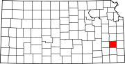 | |
| Unincorporated communities | ||
| Townships | ||
| Authority control: Geographic |
|---|