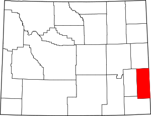
Goshen County, Wyoming
Goshen County | |
|---|---|
 U.S. Post Office in Torrington, Wyoming | |
 Location within the U.S. state of Wyoming | |
 Wyoming's location within the U.S. | |
| Coordinates: 42°05′N 104°22′W / 42.09°N 104.36°W | |
| Country | |
| State | |
| Founded | February 21, 1911 (authorized) 1913 (organized) |
| Named for | Land of Goshen |
| Seat | Torrington |
| Largest city | Torrington |
| Area | |
| • Total | 2,232 sq mi (5,780 km2) |
| • Land | 2,225 sq mi (5,760 km2) |
| • Water | 6.8 sq mi (18 km2) 0.3% |
| Population (2020) | |
| • Total | 12,498 |
| • Density | 5.6/sq mi (2.2/km2) |
| Time zone | UTC−7 (Mountain) |
| • Summer (DST) | UTC−6 (MDT) |
| Congressional district | At-large |
| Website | goshencounty |
Goshen County is a county in the U.S. state of Wyoming. As of the 2020 census, 12,498 people lived there.[1] Its county seat is Torrington.[2] It is on the eastern border with Nebraska.
Communities[change | change source]
City[change | change source]
- Torrington (county seat)
Towns[change | change source]
Census-designated places[change | change source]
Unincorporated communities[change | change source]
References[change | change source]
- ↑ "QuickFacts: Goshen County, Wyoming". United States Census Bureau. Retrieved January 21, 2024.
- ↑ National Association of Counties. "NACo County Explorer". Retrieved January 21, 2024.
Other websites[change | change source]
- Official county website Archived 2019-10-13 at the Wayback Machine

