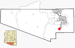
Green Valley, Arizona
Green Valley, Arizona | |
|---|---|
 Tile rooftop in Green Valley | |
 Location in Pima County and Arizona | |
| Coordinates: 31°51′N 111°0′W / 31.850°N 111.000°W | |
| Country | United States |
| State | Arizona |
| County | Pima |
| Area | |
| • Total | 19.75 sq mi (51.14 km2) |
| • Land | 19.73 sq mi (51.10 km2) |
| • Water | 0.01 sq mi (0.04 km2) |
| Elevation | 2,980 ft (908 m) |
| Population | |
| • Total | 22,616 |
| • Density | 1,146.27/sq mi (442.59/km2) |
| Time zone | UTC−7 (Mountain (MST)) |
| ZIP codes | 85614, 85622 |
| Area code | 520 |
| FIPS code | 04-29710 |
| GNIS feature ID | 37327 |
Green Valley is a census-designated place (CDP) in Pima County, Arizona, United States. The population was 22,616 at the 2020 census.[2]
References[change | change source]
- ↑ "2020 U.S. Gazetteer Files". United States Census Bureau. Retrieved October 29, 2021.
- ↑ 2.0 2.1 "QuickFacts: Green Valley CDP, Arizona". United States Census Bureau. Retrieved September 8, 2023.


