
Canton of Grevenmacher
(Redirected from Grevenmacher (canton))
Canton of Grevenmacher
Kanton Gréiwemaacher | |
|---|---|
 Coat of arms | |
 | |
| Coordinates: 49°36′N 6°24′E / 49.600°N 6.400°E | |
| Country | Luxembourg |
| Legislative constituency | Est |
| LAU 1 | LU00011 |
| Capital | Grevenmacher |
| Communes (cities in bold) | Betzdorf Biwer Flaxweiler Grevenmacher Junglinster Manternach Mertert Wormeldange |
| Area | |
| • Total | 211.4 km2 (81.6 sq mi) |
| • Rank | 7th of 12 |
| Highest elevation | 411 m (1,348 ft) |
| Lowest elevation | 132 m (433 ft) |
| Population (2023) | |
| • Total | 32,524 |
| • Rank | 6th of 12 |
| • Density | 150/km2 (400/sq mi) |
| • Rank | 7th of 12 |
Grevenmacher (Luxembourgish: Gréiwemaacher) is a canton in Luxembourg. Its capital is Grevenmacher.
Geography[change | change source]
With an area of 211.4 km2 (81.6 sq mi),[1] and a population (2017) of 29,525, the Grevenmacher canton has a population density of 139.7 inhabitants/km².[2]
It is bordered on the north by the Echternach canton, on the east by the German district of Trier-Saarburg (part of the Land of Rhineland-Palatinate), on the south by the Remich canton, and on the west by the Luxembourg district.
Places next to Canton of Grevenmacher | ||||||||||
|---|---|---|---|---|---|---|---|---|---|---|
| ||||||||||
Communes[change | change source]
The Grevenmacher canton consists of the following 8 communes (2017 population).[2]
- Betzdorf (3,810)
- Biwer (1,813)
- Flaxweiler (2,060)
- Grevenmacher (4,923)
- Junglinster (7,537)
- Manternach (2,068)
- Mertert (4,530)
- Wormeldange (2,784)
Gallery[change | change source]
-
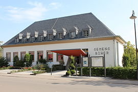 Town hall of Biwer
 -
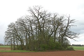
 Oak tree in Godbrange, Junglinster
 -


Related pages[change | change source]
References[change | change source]
Wikimedia Commons has media related to Canton of Grevenmacher.
- ↑ "Surface area of the cantons and municipalities". Statistics Portal - Grand Duchy of Luxembourg. Retrieved 20 May 2016.
- ↑ 2.0 2.1 "Population by canton and municipality 1821 - 2017". Statistics Portal - Grand Duchy of Luxembourg. Retrieved 30 December 2017.