
Hürben (Krumbach)
Hürben, today the eastern part of Krumbach in Bavarian Swabia, was an independent village before it was in the neighbouring town of Krumbach in the year 1902. The Kammel was in most parts of the border between Krumbach and Hürben.
Gallery[change | change source]
-
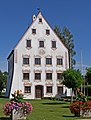 moated castle of Hürben
 -
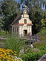 Mühlkapelle at the stream Kammel
 -
 church St. Ulrich
 -
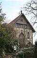 Lindlkirche
 -
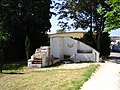 memorial place at the place of the former synagogue


Quarters of Krumbach (Schwaben) | ||
|---|---|---|
Krumbach | Hürben | Krumbad | Attenhausen | Billenhausen | Edenhausen | Hirschfelden | Hohenraunau | Niederraunau | ||
48°14′45″N 10°22′10″E / 48.24583°N 10.36944°E
| Authority control: International |
|---|