Hampshire County, Massachusetts
Hampshire County | |
|---|---|
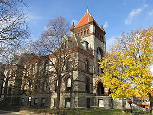
 Old Hampshire County Courthouse | |
 Location within the U.S. state of Massachusetts | |
 Massachusetts's location within the U.S. | |
| Coordinates: 42°20′N 72°40′W / 42.34°N 72.66°W | |
| Country | |
| State | |
| Founded | 1662 |
| Named for | Hampshire, England |
| Seat | Northampton |
| Largest town | Amherst |
| Area | |
| • Total | 545 sq mi (1,410 km2) |
| • Land | 527 sq mi (1,360 km2) |
| • Water | 18 sq mi (50 km2) 3.3% |
| Population (2020) | |
| • Total | 162,308 |
| • Density | 308.0/sq mi (118.9/km2) |
| Time zone | UTC−5 (Eastern) |
| • Summer (DST) | UTC−4 (EDT) |
| Congressional districts | 1st, 2nd |
Hampshire County is a county in the U.S. state of Massachusetts. As of the 2020 census, the population was 162,308.[1] The county seat is Northampton.[2] It is named after the English county Hampshire.[3]
References[change | change source]
- ↑ "QuickFacts: Hampshire County, Massachusetts". United States Census Bureau. Retrieved January 3, 2024.
- ↑ "Find a County". National Association of Counties. Retrieved June 7, 2011.
- ↑ Gannett, Henry (1905). The Origin of Certain Place Names in the United States. Govt. Print. Off. p. 148.
Wikimedia Commons has media related to Hampshire County, Massachusetts.


