Hans Island
Native name: | |
|---|---|
 Hans Island from the east (Greenlandic) side | |
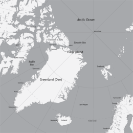
 Location of Hans Island, between Greenland and Ellesmere Island | |
| Geography | |
| Coordinates | 80°49′35″N 66°27′30″W / 80.82639°N 66.45833°W |
| Area | 1.3 km2 (0.50 sq mi) |
| Length | 1,290 m (4230 ft) |
| Width | 1,199 m (3934 ft) |
| Administration | |
| Territory | |
| Region | Qikiqtaaluk |
| Queen of Canada | Elizabeth II |
| Constituent country | |
| Municipality | Avannaata |
| Queen of Denmark | Margrethe II |
| Demographics | |
| Population | Uninhabited (2022) |
Hans Island (Inuktitut and Greenlandic: Tartupaluk; Inuktitut syllabics: ᑕᕐᑐᐸᓗᒃ; Danish: Hans Ø; French: Île Hans) is an uninhabited island with an area of 1.3 km2 (0.50 sq mi). It is in the centre of the Kennedy Channel of Nares Strait. It is within the territorial waters of both Canada and Greenland (Denmark).
The island has likely been part of Inuit hunting grounds since the 14th century.[1] It was claimed by both Canada and Denmark[2] until June 14, 2022, when both countries agreed to split the island in half.
References[change | change source]
- ↑ "Whose Hans?". Canadian Geographic. Archived from the original on January 5, 2013.
- ↑ McKernan, Bethan (13 November 2015). "Canada and Denmark are locked in an adorable war". i100.co.uk. Retrieved 14 November 2015.

