Happy Valley, Oregon
Happy Valley, Oregon | |
|---|---|
 Happy Valley, on the southeast flank of Mount Scott | |
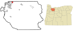
 Location in Oregon | |
| Coordinates: 45°26′09″N 122°30′29″W / 45.43583°N 122.50806°W | |
| Country | United States |
| State | Oregon |
| County | Clackamas |
| Incorporated | 1965 |
| Area | |
| • Total | 11.65 sq mi (30.17 km2) |
| • Land | 11.60 sq mi (30.04 km2) |
| • Water | 0.05 sq mi (0.12 km2) |
| Elevation | 643 ft (196 m) |
| Population | |
| • Total | 23,733 |
| • Density | 2,046.12/sq mi (789.99/km2) |
| Time zone | UTC-8 (Pacific (PST)) |
| • Summer (DST) | UTC-7 (PDT) |
| ZIP code | 97086 |
| Area code(s) | 503 and 971 |
| FIPS code | 41-32050 |
| GNIS feature ID | 2410698[2] |
| Website | happyvalleyor.gov |
Happy Valley is a suburban city in the Portland, Oregon metropolitan area.
References[change | change source]
- ↑ "ArcGIS REST Services Directory". United States Census Bureau. Retrieved October 12, 2022.
- ↑ 2.0 2.1 U.S. Geological Survey Geographic Names Information System: Happy Valley, Oregon
- ↑ "QuickFacts: Happy Valley city, Oregon". United States Census Bureau. Retrieved February 22, 2024.
