Haverhill, New Hampshire
Haverhill, New Hampshire | |
|---|---|
Town | |
 Haverhill municipal offices | |
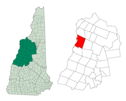
 Location in Grafton County, New Hampshire | |
| Coordinates: 44°02′03″N 72°03′50″W / 44.03417°N 72.06389°W | |
| Country | United States |
| State | New Hampshire |
| County | Grafton |
| Incorporated | 1763 |
| Villages | East Haverhill Haverhill Corner Mountain Lakes North Haverhill Pike Woodsville |
| Area | |
| • Total | 52.4 sq mi (135.6 km2) |
| • Land | 51.0 sq mi (132.1 km2) |
| • Water | 1.4 sq mi (3.5 km2) 2.62% |
| Elevation | 640 ft (200 m) |
| Population (2020)[2] | |
| • Total | 4,585 |
| • Density | 90/sq mi (34.7/km2) |
| Time zone | UTC-5 (EST) |
| • Summer (DST) | UTC-4 (EDT) |
| ZIP codes | |
| Area code | 603 |
| FIPS code | 33-34820 |
| GNIS feature ID | 0873621 |
| Website | www |
Haverhill is a town in Grafton County, New Hampshire, United States. The population was 4,585 at the 2020 census.[2]
References[change | change source]
- ↑ "2021 U.S. Gazetteer Files – New Hampshire". United States Census Bureau. Retrieved November 29, 2021.
- ↑ 2.0 2.1 "Haverhill town, Grafton County, New Hampshire: 2020 DEC Redistricting Data (PL 94-171)". U.S. Census Bureau. Retrieved November 29, 2021.


