Havryshivka Vinnytsia International Airport
Havryshivka Vinnytsia International Airport Міжнародний Аеропорт «Вінниця» (Гавришівка) | |||||||||||
|---|---|---|---|---|---|---|---|---|---|---|---|
 | |||||||||||
| Summary | |||||||||||
| Airport type | Public | ||||||||||
| Serves | Vinnytsia, Ukraine | ||||||||||
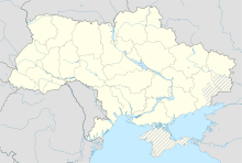
| Location | Vinnytsia Oblast | ||||||||||
| Elevation AMSL | 297 m / 974 ft | ||||||||||
| Coordinates | 49°14′23″N 028°36′50″E / 49.23972°N 28.61389°E | ||||||||||
| Website | airvinnytsia.com | ||||||||||
| Map | |||||||||||
| Runways | |||||||||||
| |||||||||||
| Statistics (2018) | |||||||||||
| |||||||||||
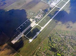
Vinnytsia International Airport (Ukrainian: Міжнародний Аеропорт «Вінниця» (Гавришівка)) (IATA: VIN, ICAO: UKWW) was an airport near the village of Havryshivka. It served for the city of Vinnytsia in the Vinnytsia region of Ukraine.
The resort was opened in 1983 and was used for local, interregional and later international routes. Regular flights were operated until 1999.
On March 25, 2018, UIA began operating regular flights between Kyiv's Boryspil Airport and Vinnytsia.[1]
The airport was destroyed on 6 March 2022 when it was hit by eight missiles during the 2022 Russian invasion of Ukraine.[2]
References[change | change source]
- ↑ "МАУ вводить найкоротший рейс Київ – Вінниця". 1NEWS.COM.UA (in Ukrainian). 2017-12-22. Archived from the original on 2017-12-25. Retrieved 2022-06-29.
- ↑ Orlova, Violeta (6 March 2022). "Аэропорт под Винницей полностью уничтожен - Зеленский" [Airport near Vinnitsa completely destroyed - Zelensky]. UNIAN (in Russian). Archived from the original on 6 March 2022. Retrieved 6 March 2022.

