
Hochdorf, Switzerland
Hochdorf | |
|---|---|
 Coat of arms | |
Location of Hochdorf  | |
 Hochdorf  Hochdorf | |
| Coordinates: 47°10′N 8°17′E / 47.167°N 8.283°E | |
| Country | Switzerland |
| Canton | Lucerne |
| District | Hochdorf |
| Area | |
| • Total | 10.30 km2 (3.98 sq mi) |
| Elevation | 491 m (1,611 ft) |
| Highest elevation (East of Urswil) | 513 m (1,683 ft) |
| Lowest elevation | 464 m (1,522 ft) |
| Population (31 December 2018)[2] | |
| • Total | 9,844 |
| • Density | 960/km2 (2,500/sq mi) |
| Time zone | UTC+01:00 (Central European Time) |
| • Summer (DST) | UTC+02:00 (Central European Summer Time) |
| Postal code(s) | 6280-6283 |
| SFOS number | 1031 |
| Localities | Hochdorf Dorf, Baldegg, Ligschwil, Urswil |
| Surrounded by | Ballwil, Eschenbach, Hohenrain, Rain, Römerswil |
| Website | www Profile (in German), SFSO statistics |
Hochdorf is a municipality of the district of Hochdorf in the canton of Lucerne in Switzerland.
Gallery[change | change source]
-
 Hochdorf
 -
 Church of St. Martin
 -
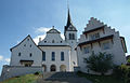
 Kloster Baldegg


References[change | change source]
- ↑ 1.0 1.1 "Arealstatistik Standard - Gemeinden nach 4 Hauptbereichen". Federal Statistical Office. Retrieved 13 January 2019.
- ↑ "Ständige Wohnbevölkerung nach Staatsangehörigkeitskategorie Geschlecht und Gemeinde; Provisorische Jahresergebnisse; 2018". Federal Statistical Office. 9 April 2019. Retrieved 11 April 2019.
Other websites[change | change source]
![]() Media related to Hochdorf LU at Wikimedia Commons
Media related to Hochdorf LU at Wikimedia Commons
- Official website (in German)