Igrejinha
Município de Igrejinha | |
|---|---|
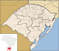
 Location in Rio Grande do Sul, Brazil | |
| Coordinates: 29°34′26″S 50°47′24″W / 29.57389°S 50.79000°W | |
| Country | Brazil |
| Region | South |
| State | Rio Grande do Sul |
| Emanciped | June 1, 1964 |
| Government | |
| • Mayor | Elir Domingo Girardi (PTB) |
| Area | |
| • Total | 136.816 km2 (52.825 sq mi) |
| Elevation | 18 m (59 ft) |
| Population (2006 est.)[1] | |
| • Total | 31,389 |
| • Density | 229.4/km2 (594/sq mi) |
| Time zone | UTC-3 (UTC-3) |
| • Summer (DST) | UTC-2 (UTC-2) |
| Website | Prefeitura de Igrejinha |
Igrejinha is a Brazilian city of the state of Rio Grande do Sul. It has 31 389 inhabitants. It has an area of 136.816 square kilometres (52.825 square miles).
Sources[change | change source]
- ↑ 1.0 1.1 (in Portuguese) Cidades@ Archived 2017-08-25 at the Wayback Machine, Brazilian Institute of Geography and Statistics, Accessed on 2007-09-25.


