
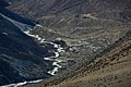
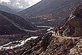
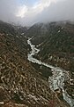
Imja Khola
| Imja Khola | |
|---|---|
 Imja Khola river with Ama Dablam in the background | |
| Location | |
| Country | Nepal |
| Physical characteristics | |
| Source | |
| - location | Imja Glacier[1] |
| Mouth | |
| - location | Dudh Kosi at Tengboche |
| - coordinates | 27°47′35″N 86°42′58″E / 27.793°N 86.716°E |
| Basin features | |
| River system | Koshi River |
The Imja Khola (Nepali: इम्जा खोला) is a tributary of Dudh Kosi river which flows in estern part of Nepal. This river is on the trekking route Which passes through the Rhododendron forest in Everest base camp region.
- Imja Khola
-

-
-

-
-


References[change | change source]
- ↑ Bradley, Mayhew; "Trekking in the Nepal Himalaya" ;(2009); 9 edição; pp 86-94-97-118-122; Lonely Planet; ISBN 9781741041880.