Ironwood, Michigan
Ironwood, Michigan | |
|---|---|
 Downtown along Aurora Street (Bus. US 2) | |
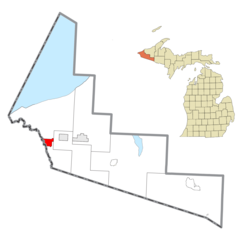
 Location within Gogebic County | |
| Coordinates: 46°27′21″N 90°9′34″W / 46.45583°N 90.15944°W | |
| Country | United States |
| State | Michigan |
| County | Gogebic |
| Settled | 1885 |
| Incorporated | 1887 (village) 1889 (city) |
| Government | |
| • Type | City commission |
| Area | |
| • Total | 6.58 sq mi (17.04 km2) |
| • Land | 6.58 sq mi (17.04 km2) |
| • Water | 0.00 sq mi (0.00 km2) |
| Elevation | 1,506 ft (459 m) |
| Population | |
| • Total | 5,045 |
| • Density | 766.95/sq mi (296.13/km2) |
| Time zone | UTC−6 (Central (CST)) |
| • Summer (DST) | UTC−5 (CDT) |
| ZIP code(s) | 49938 |
| Area code | 906 |
| FIPS code | 26-41060[3] |
| GNIS feature ID | 0629087[4] |
| Website | Official website |
Ironwood is a city in Gogebic County in the U.S. state of Michigan, about 18 miles (29 km) south of Lake Superior. The population was 5,045 at the 2020 census.[2]
References[change | change source]
- ↑ "2020 U.S. Gazetteer Files". United States Census Bureau. Retrieved May 21, 2022.
- ↑ 2.0 2.1 "Profile of General Population and Housing Characteristics: 2020 Demographic Profile Data (DP-1): Ironwood city, Michigan". United States Census Bureau. Retrieved February 19, 2024.
- ↑ "U.S. Census website". United States Census Bureau. Retrieved January 31, 2008.
- ↑ U.S. Geological Survey Geographic Names Information System: Ironwood, Michigan


