Ittenheim
Ittenheim | |
|---|---|
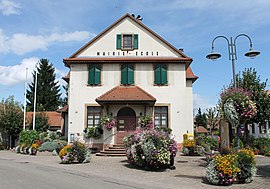
 The town hall and school in Ittenheim | |
| Coordinates: 48°36′18″N 7°35′43″E / 48.605°N 7.5953°E | |
| Country | France |
| Region | Grand Est |
| Department | Bas-Rhin |
| Arrondissement | Saverne |
| Canton | Bouxwiller |
| Intercommunality | Kochersberg |
| Government | |
| • Mayor (2020–2026) | Alain Grosskost |
| Area 1 | 6.71 km2 (2.59 sq mi) |
| Population (Jan. 2019)[1] | 2,112 |
| • Density | 310/km2 (820/sq mi) |
| Time zone | UTC+01:00 (CET) |
| • Summer (DST) | UTC+02:00 (CEST) |
| INSEE/Postal code | 67226 /67117 |
| Elevation | 152–212 m (499–696 ft) |
| 1 French Land Register data, which excludes lakes, ponds, glaciers > 1 km2 (0.386 sq mi or 247 acres) and river estuaries. | |
Ittenheim is a commune. It is in Grand Est in the Bas-Rhin department in northeast France.
Geography[change | change source]
Ittenheim is placed ten kilometres (six miles) to the west of Strasbourg. The commune is crossed by the departmental road RD1004 (formerly Route nationale 4).
The neighbouring communes are Hurtigheim to the north, Oberschaeffolsheim to the east, Achenheim to the southeast, Breuschwickersheim to the south, Osthoffen to the southwest, Handschuheim to the west and Furdenheim to the northwest.
Sights[change | change source]
- The Protestant church of Saint Gall, dating from the 18th century
- Silbermann organ at St. Gall church, dating from the 18th century
-
Protestant church of Saint Gall
-
Silbermann organ at St. Gall church
Related pages[change | change source]
References[change | change source]
- ↑ "Populations légales 2019". The National Institute of Statistics and Economic Studies. 29 December 2021.
Wikimedia Commons has media related to Ittenheim.


