
Kewaunee County, Wisconsin
Kewaunee County | |
|---|---|
 Kewaunee County Courthouse | |
 Location within the U.S. state of Wisconsin | |
 Wisconsin's location within the U.S. | |
| Coordinates: 44°35′N 87°26′W / 44.59°N 87.44°W | |
| Country | |
| State | |
| Founded | 1859 |
| Seat | Kewaunee |
| Largest city | Algoma |
| Area | |
| • Total | 1,084 sq mi (2,810 km2) |
| • Land | 343 sq mi (890 km2) |
| • Water | 742 sq mi (1,920 km2) 68% |
| Population | |
| • Total | 20,563 |
| • Density | 60.0/sq mi (23.2/km2) |
| Time zone | UTC−6 (Central) |
| • Summer (DST) | UTC−5 (CDT) |
| Congressional district | 8th |
| Website | www |
Kewaunee County is a county in the U.S. state of Wisconsin. As of 2020, 20,563 people lived there.[1] Its county seat is Kewaunee.[2] Kewaunee County is part of the Green Bay Metropolitan Statistical Area.
Geography[change | change source]
| Historical population | |||
|---|---|---|---|
| Census | Pop. | %± | |
| 1860 | 5,530 | — | |
| 1870 | 10,128 | 83.1% | |
| 1880 | 15,807 | 56.1% | |
| 1890 | 16,153 | 2.2% | |
| 1900 | 17,212 | 6.6% | |
| 1910 | 16,784 | −2.5% | |
| 1920 | 16,091 | −4.1% | |
| 1930 | 16,037 | −0.3% | |
| 1940 | 16,680 | 4.0% | |
| 1950 | 17,366 | 4.1% | |
| 1960 | 18,282 | 5.3% | |
| 1970 | 18,961 | 3.7% | |
| 1980 | 19,539 | 3.0% | |
| 1990 | 18,878 | −3.4% | |
| 2000 | 20,187 | 6.9% | |
| 2010 | 20,574 | 1.9% | |
| 2020 | 20,563 | −0.1% | |
| U.S. Decennial Census[3] 1790–1960[4] 1900–1990[5] 1990–2000[6] 2010–2020[1] | |||
The county has a total area of 1,085 square miles (2,810.1 km2). Of this, 343 square miles (888.4 km2) is land and 742 square miles (1,921.8 km2) (68.41%) is water.
Cities, villages, and towns[change | change source]
- Ahnapee
- Algoma
- Carlton
- Casco (town)
- Casco
- Franklin
- Kewaunee
- Lincoln
- Luxemburg (town)
- Luxemburg
- Montpelier
- Pierce
- Red River
- West Kewaunee
Unincorporated communities[change | change source]
- Alaska
- Bay View
- Birchwood
- Bolt
- Bruemmerville
- Casco Junction
- Cherneyville
- Clyde
- Curran
- Duvall
- Dyckesville (partial)
- East Krok
- Ellisville
- Euren
- Frog Station
- Gregorville
- Kodan
- Krok
- Lincoln
- Neuren
- Norman
- Pilsen
- Rankin
- Rio Creek
- Rosiere (partial)
- Rostok
- Ryans Corner
- Slovan
- Stangelville
- Thiry Daems
- Tisch Mills (partial)
- Tonet
- Walhain
Images[change | change source]
-
 Kewaunee County Courthouse
 -
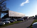 Kewaunee County fairgrounds
 -
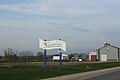 Welcome sign on WIS 54, farm in the background


References[change | change source]
- ↑ 1.0 1.1 1.2 "QuickFacts: Kewaunee County, Wisconsin". United States Census Bureau. Retrieved January 21, 2024.
- ↑ "Find a County". National Association of Counties. Retrieved 2008-01-31.
- ↑ "U.S. Decennial Census". United States Census Bureau. Retrieved August 5, 2015.
- ↑ "Historical Census Browser". University of Virginia Library. Retrieved August 5, 2015.
- ↑ Forstall, Richard L., ed. (March 27, 1995). "Population of Counties by Decennial Census: 1900 to 1990". United States Census Bureau. Retrieved August 5, 2015.
- ↑ "Census 2000 PHC-T-4. Ranking Tables for Counties: 1990 and 2000" (PDF). United States Census Bureau. April 2, 2001. Archived (PDF) from the original on 2022-10-09. Retrieved August 5, 2015.
Other websites[change | change source]
Wikimedia Commons has media related to Kewaunee County, Wisconsin.
- Kewaunee County
- Northeast Wisconsin Historical County Plat Maps & Atlases University of Wisconsin Digital Collections Center
Places next to Kewaunee County, Wisconsin | ||||||||||
|---|---|---|---|---|---|---|---|---|---|---|
| ||||||||||
