Knightsbridge
| Knightsbridge | |
|---|---|
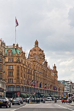
 Harrods on Brompton Road | |
| Location within Greater London | |
| Population | 9,270 (2011 Census. Knightsbridge and Belgravia Ward)[1] |
| OS grid reference | TQ275797 |
| London borough | |
| Ceremonial county | Greater London |
| Region | |
| Country | England |
| Sovereign state | United Kingdom |
| Post town | LONDON |
| Postcode district | SW1X, SW3, SW7 |
| Dialling code | 020 |
| Police | Metropolitan |
| Fire | London |
| Ambulance | London |
| UK Parliament | |
| London Assembly | |
Knightsbridge is a residential, business shopping district in central London.[2] It is south of Hyde Park. It is part of the London Plan.[3]
References[change | change source]
- ↑ "City of Westminster ward population 2011". Neighbourhood Statistics. Office for National Statistics. Archived from the original on 21 October 2016. Retrieved 15 October 2016.
- ↑ "London's Places" (PDF). The London Plan. Greater London Authority. 2011. p. 46. Archived from the original (PDF) on 6 September 2015. Retrieved 27 May 2014.
- ↑ Mayor of London (2008). "Central activities zone policies". London Plan. Greater London Authority. Archived from the original on 28 May 2014. Retrieved 27 May 2014.

