
Konnersreuth
Konnersreuth | |
|---|---|
 Coat of arms | |
Location of Konnersreuth within Tirschenreuth district  | |
 Konnersreuth  Konnersreuth | |
| Coordinates: 50°1′N 12°14′E / 50.017°N 12.233°E | |
| Country | Germany |
| State | Bavaria |
| Admin. region | Oberpfalz |
| District | Tirschenreuth |
| Subdivisions | 9 Ortsteile |
| Government | |
| • Mayor (2020–26) | Maximilian Bindl[1] |
| Area | |
| • Total | 23.32 km2 (9.00 sq mi) |
| Elevation | 573 m (1,880 ft) |
| Population (2022-12-31)[2] | |
| • Total | 1,725 |
| • Density | 74/km2 (190/sq mi) |
| Time zone | UTC+01:00 (CET) |
| • Summer (DST) | UTC+02:00 (CEST) |
| Postal codes | 95692 |
| Dialling codes | 09632 |
| Vehicle registration | TIR |
| Website | www.konnersreuth.de |
Konnersreuth is a municipality in Tirschenreuth in Bavaria, Germany.
It is in the northeast foothills of the Steinwald mountains between the Fichtelgebirge mountains and the Upper Palatinate Forest, close to the Czech border.
Gallery[change | change source]
-
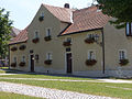 House where Therese Neumann was born
 -
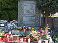 Grave of Therese Neumann
 -
 Theresianum Abbey
 -
 View of Konnersreuth


References[change | change source]
- ↑ Liste der ersten Bürgermeister/Oberbürgermeister in kreisangehörigen Gemeinden, Bayerisches Landesamt für Statistik, 15 July 2021.
- ↑ Genesis Online-Datenbank des Bayerischen Landesamtes für Statistik Tabelle 12411-003r Fortschreibung des Bevölkerungsstandes: Gemeinden, Stichtag (Einwohnerzahlen auf Grundlage des Zensus 2011)
Towns and municipalities in Tirschenreuth (district) | ||
|---|---|---|
| International | |
|---|---|
| National | |