
Kosciusko, Mississippi
Kosciusko, Mississippi | |
|---|---|
 Welcome sign located on Mississippi Highway 12 | |
 Location of Kosciusko, Mississippi | |
| Coordinates: 33°3′29″N 89°35′18″W / 33.05806°N 89.58833°W | |
| Country | United States |
| State | Mississippi |
| County | Attala |
| Named for | Tadeusz Kościuszko |
| Area | |
| • Total | 7.55 sq mi (19.56 km2) |
| • Land | 7.54 sq mi (19.53 km2) |
| • Water | 0.01 sq mi (0.02 km2) |
| Elevation | 479 ft (146 m) |
| Population | |
| • Total | 7,114 |
| • Density | 943.38/sq mi (364.22/km2) |
| Time zone | UTC-6 (Central (CST)) |
| • Summer (DST) | UTC-5 (CDT) |
| ZIP code | 39090 |
| Area code | 662 |
| FIPS code | 28-38320 |
| GNIS feature ID | 0672213 |
| Website | kosciusko |
Kosciusko /ˌkɒsiˈʌskoʊ/ is a city in Attala County, Mississippi, United States. James Meredith and Oprah Winfrey were born there. The population was 7,114 at the 2020 census.[2] It is the county seat of Attala County.[3]
Name[change | change source]
Kosciusko is named for General Tadeusz Kościuszko, a Polish-Lithuanian officer. He served with the Continental Army during the American Revolution.[4] His name was changed to 'Kosciusko' to make it easier to write in English. The settlement was originally named Red Bud Springs for one of three natural springs that were in the city.[source?]
History[change | change source]
Kosciusko first developed along the historic Natchez Trace used by generations of Native Americans and later European settlers. The modern Natchez Trace Parkway also passes through the city.
During the 19th century, cotton was the most common crop. It is still important in the area.[source?]
Magnolia Bible College was in the city from 1976 to 2008. Kosciusko is the birthplace of civil rights activist James Meredith and TV series host and cultural leader Oprah Winfrey.
Kosciusko has hosted the Central Mississippi Fair for over 100 years.[5]
Geography[change | change source]
Kosciusko is at 33°3′29″N 89°35′18″W / 33.05806°N 89.58833°W (33.058108, -89.588301),[6] along the Yockanookany River. It is northeast of Jackson and southwest of Starkville. It is 20 miles / 32 kilometers from I-55 at Durant.
According to the United States Census Bureau, the area of Kosciusko is 7.6 square miles (20 km2). 7.5 square miles (19 km2) is land and 0.13% is water.
Education[change | change source]
The city of Kosciusko is part of the Kosciusko School District.
Blues Highway[change | change source]
Kosciusko has been part of the Mississippi Blues Trail since 2009.[7]
Notable people[change | change source]
- Dave Barnes, singer-songwriter and musician for Razor & Tie
- Billy Ray Bates, former NBA shooting guard for the Portland Trail Blazers, the Washington Bullets, and the Los Angeles Lakers. He also played in several other countries, most notably for the Crispa Redmanizers and Ginebra San Miguel of the Philippine Basketball Association.[8]
- Eva Webb Dodd, Anna Boyd Ellington, and Mary Comfort Leonard, founders of the Delta Gamma fraternity
- Clarence Harmon, former NFL walking back for the Washington Redskins
- James Meredith, civil rights leader
- Charlie Musselwhite, blues harmonica player and band leader
- Topher Payne, playwright[9]
- Oprah Winfrey, television host, personality, and cultural leader
- Marc Woodard, former NFL linebacker for the Philadelphia Eagles
Climate[change | change source]
The climate is characterized by hot, humid summers and generally mild to cool winters. According to the Köppen Climate Classification system, Kosciusko has a humid subtropical climate, abbreviated "Cfa" on climate maps.[10]
The data below are from the WRCC, compiled from 1893 to the time this chart was created (July 2018).[11]
| Climate data for Kosciusko, MS | |||||||||||||
|---|---|---|---|---|---|---|---|---|---|---|---|---|---|
| Month | Jan | Feb | Mar | Apr | May | Jun | Jul | Aug | Sep | Oct | Nov | Dec | Year |
| Record high °F (°C) | 85 (29) |
85 (29) |
92 (33) |
98 (37) |
102 (39) |
109 (43) |
108 (42) |
109 (43) |
109 (43) |
98 (37) |
89 (32) |
84 (29) |
109 (43) |
| Average high °F (°C) | 55.5 (13.1) |
58.8 (14.9) |
67.5 (19.7) |
75.5 (24.2) |
82.5 (28.1) |
89.4 (31.9) |
91.5 (33.1) |
91.6 (33.1) |
87.2 (30.7) |
77.3 (25.2) |
65.9 (18.8) |
57.0 (13.9) |
75.0 (23.9) |
| Average low °F (°C) | 33.6 (0.9) |
35.7 (2.1) |
42.8 (6.0) |
50.7 (10.4) |
58.8 (14.9) |
66.4 (19.1) |
69.4 (20.8) |
68.6 (20.3) |
62.6 (17.0) |
50.1 (10.1) |
40.8 (4.9) |
34.8 (1.6) |
51.2 (10.7) |
| Record low °F (°C) | −14 (−26) |
−8 (−22) |
10 (−12) |
24 (−4) |
36 (2) |
41 (5) |
53 (12) |
50 (10) |
37 (3) |
20 (−7) |
12 (−11) |
0 (−18) |
−14 (−26) |
| Average precipitation inches (mm) | 5.36 (136) |
5.27 (134) |
5.99 (152) |
5.35 (136) |
4.68 (119) |
3.66 (93) |
5.00 (127) |
3.76 (96) |
3.33 (85) |
3.19 (81) |
4.45 (113) |
5.41 (137) |
55.45 (1,409) |
| Average snowfall inches (cm) | 1.2 (3.0) |
0.3 (0.76) |
0.3 (0.76) |
0 (0) |
0 (0) |
0 (0) |
0 (0) |
0 (0) |
0 (0) |
0 (0) |
0 (0) |
0.4 (1.0) |
2.2 (5.52) |
| Source: https://wrcc.dri.edu/cgi-bin/cliMAIN.pl?ms4776 | |||||||||||||
Gallery[change | change source]
-
 Attala County Courthouse
 -
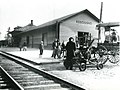 Illinois Central Depot in Kosciusko, 1920
.jpg)

References[change | change source]
- ↑ "2020 U.S. Gazetteer Files". United States Census Bureau. Retrieved July 24, 2022.
- ↑ 2.0 2.1 "QuickFacts: Kosciusko city, Mississippi". United States Census Bureau. Retrieved February 10, 2024.
- ↑ National Association of Counties. "NACo County Explorer". Retrieved February 10, 2024.
- ↑ Gannett, Henry (1905). The Origin of Certain Place Names in the United States. Government Printing Office. p. 177.
- ↑ "Central Mississippi Fair". Retrieved 26 March 2019.
- ↑ "US Gazetteer files: 2010, 2000, and 1990". United States Census Bureau. 2011-02-12. Retrieved 2011-04-23.
- ↑ Dees, Leslie N. (January 23, 2009) Kosciusko to be featured on Blues Trail. The Star Herald
- ↑ "NBA Players: Billy Ray Bates Profile and Basic Stats". Retrieved 28 February 2017.
- ↑ Topher Payne - Mississippi Arts & Entertainment Center Archived 2015-12-10 at the Wayback Machine. Msarts.org (2013-11-21). Retrieved on 2015-12-25.
- ↑ "Kosciusko, Mississippi Köppen Climate Classification (Weatherbase)". Weatherbase. Retrieved 21 July 2015.
- ↑ "KOSCIUSKO, MISSISSIPPI - Climate Summary". wrcc.dri.edu. Retrieved 2018-07-24.
Other websites[change | change source]
Municipalities and communities of Attala County, Mississippi, United States | ||
|---|---|---|
| Cities |  | |
| Towns | ||
| Unincorporated communities | ||
| Ghost towns | ||
| Indian reservation | ||
| Footnotes | ‡This populated place also has portions in an adjacent county or counties | |