Kuroshio, Kōchi
Kuroshio
黒潮町 | |
|---|---|
Town | |
 Kuroshio Town Office | |
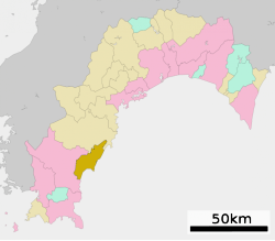
 Location of Kuroshio in Kōchi Prefecture | |
| Coordinates: 33°1′N 133°1′E / 33.017°N 133.017°E | |
| Country | Japan |
| Region | Shikoku |
| Prefecture | Kōchi Prefecture |
| District | Hata |
| Area | |
| • Total | 188.38 km2 (72.73 sq mi) |
| Population (March 31, 2017) | |
| • Total | 11,559 |
| • Density | 61/km2 (160/sq mi) |
| Time zone | UTC+9 (Japan Standard Time) |
| Website | www |
Kuroshio (黒潮町, Kuroshio-chō) is a Japanese town in Kōchi Prefecture on the Pacific coastline of the island of Shikoku.[1]
History[change | change source]
In 2006, the towns of Ōgata and Saga joined together to become the new town, Kuroshio.[2]
References[change | change source]
- ↑ Harner, Stephen Harner. "BTW, Get Ready for a 34 Meter Tsunami," Forbes (US). May 2, 2012; retrieved 2013-2-25.
- ↑ 黒潮町について; excerpt, 黒潮町は、高知県幡多郡「大方町」「佐賀町」の合併による新しい町として、平成18年3月20日に誕生しました; retrieved 2013-2-25.
Other websites[change | change source]
![]() Media related to Kuroshio, Kōchi at Wikimedia Commons
Media related to Kuroshio, Kōchi at Wikimedia Commons
- Kuroshio town website (in Japanese)


