Lake McDonald
This article does not have any sources. (September 2009) |
| Lake McDonald | |
|---|---|
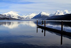
 Lake McDonald in the winter | |
| Location | Glacier National Park, Flathead County, Montana, US |
| Coordinates | 48°34′09″N 113°56′07″W / 48.56917°N 113.93528°W |
| Type | Natural lake |
| Primary inflows | Various streams |
| Primary outflows | McDonald Creek |
| Basin countries | United States |
| Max. length | 10 mi (16 km) |
| Max. width | 1 mi (1.6 km) |
| Surface area | 6,823 acres (2,761 ha) |
| Max. depth | 472 ft (144 m) |
| Surface elevation | 3,153 ft (961 m) |
Lake McDonald is the largest lake in Glacier National Park. It is in Flathead County, Montana.
Wikimedia Commons has media related to Lake McDonald.
