Lancaster, New Hampshire
Lancaster, New Hampshire | |
|---|---|
Town | |
 Main Street | |
| Motto: "The friendly town in the friendly state" | |
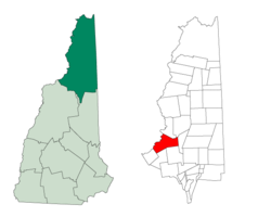
 Location in Coös County, New Hampshire | |
| Coordinates: 44°29′20″N 71°34′09″W / 44.48889°N 71.56917°W | |
| Country | United States |
| State | New Hampshire |
| County | Coös |
| Incorporated | 1763 |
| Villages |
|
| Area | |
| • Total | 51.1 sq mi (132.3 km2) |
| • Land | 50.0 sq mi (129.4 km2) |
| • Water | 1.1 sq mi (2.9 km2) 2.19% |
| Elevation | 863 ft (263 m) |
| Population (2020)[2] | |
| • Total | 3,218 |
| • Density | 64/sq mi (24.9/km2) |
| Time zone | UTC-5 (Eastern) |
| • Summer (DST) | UTC-4 (Eastern) |
| ZIP code | 03584 |
| Area code | 603 |
| FIPS code | 33-40420 |
| GNIS feature ID | 0873640 |
| Website | www |
Lancaster is a town of Coos County in the state of New Hampshire in the United States.
References[change | change source]
- ↑ "2021 U.S. Gazetteer Files – New Hampshire". United States Census Bureau. Retrieved November 9, 2021.
- ↑ "Lancaster town, Coos County, New Hampshire: 2020 DEC Redistricting Data (PL 94-171)". U.S. Census Bureau. Retrieved November 9, 2021.
Other websites[change | change source]
Wikimedia Commons has media related to Lancaster, New Hampshire.


