Land Hadeln


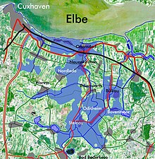
Land Hadeln is a place in Northern Germany. It is a historic landscape and used to be an administrative district. Its seat is in Otterndorf on the Lower Elbe, the lower reaches of the Elbe River, in the Elbe-Weser Triangle between the estuaries of the Elbe and Weser rivers.
References[change | change source]
Sources[change | change source]
- Eduard Rüther: Hadler Chronik. Quellenbuch zur Geschichte des Landes Hadeln. 1932; reedited Bremerhaven: 1979.
- Norbert Fischer: Im Antlitz der Nordsee – Zur Geschichte der Deiche in Hadeln; Stade 2007: ISBN 978-3-931879-34-1
