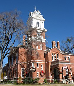
Lawrenceville, Georgia
Lawrenceville, Georgia | |
|---|---|
 Gwinnett County Courthouse | |
| Nickname: The Crepe Myrtle City | |
 Location in Gwinnett County and the state of Georgia | |
Location of Lawrenceville in Metro Atlanta | |
| Coordinates: 33°57′08″N 83°59′36″W / 33.95222°N 83.99333°W | |
| Country | United States |
| State | Georgia |
| County | Gwinnett |
| Named for | James Lawrence |
| Government | |
| • Type | Mayor-council government |
| Area | |
| • Total | 13.80 sq mi (35.73 km2) |
| • Land | 13.69 sq mi (35.46 km2) |
| • Water | 0.11 sq mi (0.28 km2) |
| Elevation | 1,083 ft (330 m) |
| Population | |
| • Total | 30,629 |
| • Density | 2,237.33/sq mi (863.83/km2) |
| Time zone | UTC-5 (Eastern (EST)) |
| • Summer (DST) | UTC-4 (EDT) |
| ZIP codes | 30042-30046, 30049 |
| Area code | 404/678/770 |
| FIPS code | 13-45488[4] |
| GNIS feature ID | 2404897[2] |
| Website | www |
Lawrenceville is a city in Gwinnett County, Georgia, in the United States. It is the county seat of Gwinnett County and is the second oldest city in the Atlanta metropolitan area. According to the 2020 census, 30,629 people lived there.[3]
References[change | change source]
- ↑ "2020 U.S. Gazetteer Files". United States Census Bureau. Archived from the original on March 18, 2021. Retrieved December 18, 2021.
- ↑ 2.0 2.1 U.S. Geological Survey Geographic Names Information System: Lawrenceville, Georgia
- ↑ 3.0 3.1 "QuickFacts: Lawrenceville city, Georgia". United States Census Bureau. Retrieved September 18, 2023.
- ↑ "U.S. Census website". United States Census Bureau. Archived from the original on July 9, 2021. Retrieved January 31, 2008.


