
Llanos
For the Supervillion, look at the page Thanos.
The Llanos (Spanish Los Llanos, "The Plains"; Spanish pronunciation: [loz ˈʝanos]) are a very big tropical grassland on flat land east of the Andes Mountains. The Llanos are in Colombia and Venezuela, in northwestern South America. Ecologists call them an ecoregion. They put them in the same group with other tropical and subtropical grasslands, savannas, and places where small trees and bushes grow.
Geography[change | change source]
The Llanos go east to west. The Andes Mountains are on the west side of the Llanos and the Venezuelan Coastal Range of mountains are north of the Llanos. The Guiana Highlands are to the southeast, and the Negro-Branco moist forests are to the southwest. To the east the Orinoco wetlands and Orinoco Delta swamp forests in the Orinoco Delta.[1]
The Orinoco River is the biggest river in the Llanos. The Orinoco River goes from west to east. The Orinoco is the biggest and most important river in Venezuela.[2]
Climate[change | change source]
The Llanos have a tropical savanna climate and tropical monsoon climate. The rainy part of the year is April to November. The dry season is from December to March. The wettest months are typically June and July. In the southwest, the llanos get as much as 3,000 millimetres (120 in) of rain per year in the southwest, 1,200 to 1,600 millimetres (47 to 63 in) in Apure State, and 800 to 1,200 millimetres (31 to 47 in) per year in the Llanos of Monagas State in the northeast. The average temperature across the whole year is 27 °C or 80.6 °F, and it does not change much with the seasons; the coldest months (June, July, December, and January) are only 2 °C or 3.6 °F colder than the hottest months.[1]
Plants[change | change source]
The Llanos have open grasslands, savannas with some trees, and small forests. The most common forest in the Llanos is gallery forests that grow next to rivers and streams. The Llanos have grasslands that flood for part of the year llano bajo or "low llano") and grasslands that stay dry (llano alto "high llano").[1]
The grass and woody plants in the llano alto are 30–100 cm high, forming bunches 10 to 30 cm apart. The ground is typically sandy and does not have many food chemicals for the plants. The llano alto covers approximately two-thirds of the Llanos in Venezuela and much of the Colombian Llanos. There are many grasses in the genus Trachypogon: species include Trachypogon plumosus, T. vestitus, Axonopus canescens, A. anceps, Andropogon selloanus, Aristida spp., Leptocoryphium lanatum, Paspalum carinatum, Sporobolus indicus, and S. cubensis, and sedges in the genera Rhynchospora and Bulbostylis. Woody plants and green plants are legumes in the genera Mimosa, Cassia, Desmodium, Eriosema, Galactia, Indigofera, Phaseolus, Stylosanthes, Tephrosia, and Zornia. The trees manteco (Byrsonima crassifolia), chaparro (Curatella americana), and alcornoque (Bowdichia virgilioides) are the most common. They can grow apart from each other. When they grow togehter, they are called matas. The matas can be as small as 12 meters across or as large as a hectare.[1]
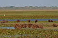
During the rainy season, parts of the Llanos can flood. The flood water can be a meter deep. Then the savannass and grasslands become wetlands. They become like the Pantanal of central South America. Water birds and other animals come to live in the flooded Llanos. The Llanos that flood are called llano bajo. The Llanos bajos have soil with more food chemicals in them, so different plants grow there, for example the grass Paspalum fasciculatum and the trees Copernicia tectorum and gallery forest trees.[1]
The gallery forests that grow near rivers have both evergreen forests on the Llanos that flood and semi-deciduous forests in the high Llanos that do not flood. Morichales are forests that flood part of the year. They have the moriche palm (Mauritia flexuosa). Vegas are evergreen forests that flood part of the year. They grow near the Orinoco river and its smaller rivers. Trees form a canopy 8 to 20 meters high, and include Inga spp., Combretum frangulifolium, Gustavia augusta, Pterocarpus sp., Etaballia dubia, Spondias mombin, and Copaifera pubiflora.[1]
Semi-deciduous forests grow above flood level. They form a canopy 12 to 15 meters high. The trees that grow there are, for example, Tabebuia billbergii, Godmania aesculifolia, Cassia moschata, Spondias mombin, Copaifera pubiflora, Bourreria cumanensis, Cordia spp., Bursera simaruba, Cochlospermum vitifolium, Hura crepitans, and Acacia glomerosa.[1]
Matorrales are places with woody plants that grow 5 to 8 meters high. There are large matorrales in the middles of the Venezuelan Llanos. Scientists think they might have been dry forests long ago. They include woody plants, for example Bourreria cumanensis, Randia aculeata, Godmania aesculifolia, Pereskia guamacho, Prosopis spp., Xylosma benthamii, Erytroxylum sp., and Cereus hexagonus.[1]
Animals[change | change source]
Fur animals live in the Llanos. For example, there are white-tailed deer (Odocoileus virginianus), giant anteaters (Myrmecophaga tridactyla), capybaras (Hydrochoerus hydrochaeris), giant armadillos (Priodontes maximus), eastern cottontail rabbits (Sylvilagus floridanus), Alston's cotton rats (Sigmodon alstoni), Hispid cotton rats (S. hispidus), Zygodontomys brevicauda, and Oecomys bicolor.[1]
Many animals live in the gallery forests that grow next to the rivers. For example, there are the collared peccary (Tayassu tajacu), white-lipped peccary (T. pecari), South American tapir (Tapirus terrestris), white-tailed deer, red brocket (Mazama americana), wedge-capped capuchin (Cebus olivaceus), Venezuelan red howler (Alouatta seniculus), large rodents like the lowland paca (Cuniculus paca), agoutis (Dasyprocta spp.), and Brazilian porcupine (Coendou prehensilis), and large cats like the puma (Puma concolor), jaguar (Panthera onca), and ocelot (Leopardus pardalis). The endangered giant otter (Pteronura brasiliensis) lives along the Orinoco River and its small rivers.[1]
Some of the largest jaguars in the world live in the Llanos. The male jaguar can weigh over 100 kg (220 lb).[3]
The Llanos long-nosed armadillo (Dasypus sabanicola) and the short-tailed opossum Monodelphis orinoci live in the Llanos.[1]
The Llanos' wetlands have about 70 species of water birds, for example the scarlet ibis.[2] Many sharp-tailed ibis (Cerbibis oxycerca) and white-bearded flycatcher (Phelpsia inornata) also live in the Llanos.
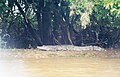
There are reptiles in the Llanos: the Orinoco crocodile (Crocodylus intermedius), spectacled caiman (Caiman crocodilus), Green anaconda (Eunectes murinus), and Arrau turtle (Podocnemis expansa) live in the flooded places.
-
-
 Spectacled caiman, Guaratico River, Venezuela


Indigenous peoples[change | change source]
Indigenous human beings who live in the Llanos include the Guahibo people in the western Llanos in Colombia and Venezuela, and the Yaruro people in the eastern Llanos in Venezuela.
Cow raising and farming[change | change source]
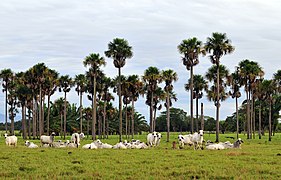
Starting with the Spanish takeover, people have brought millions of cows to the Llanos. An 1856 watercolor painting by Manuel María Paz shows cows eating grass between the palm trees.[4] The word llanero ("plainsman") became the name for the cowhands who took care of the herds. They are like the gauchos of the Pampas or the vaqueros of Spanish and Mexican Texas.
People raised so many cows on the Llanos that the grasslands changed. Human beings set fire to the grasslands to kill trees and shrubs and grow better grass for the cows. Human beings brought new grasses from other parts of the Earth because they thought they would be better for the cows to eat. For example, they brought the African grass Melinis minutiflora. Now, large parts of the Llanos are govered in African grass.[1]
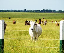
Much of the Llanos now has farms on it, for example rice and corn farms. Some of the rice fields are in the parts of the Llanos that flood.
Oil and gas[change | change source]
People look for oil and natural gas in Arauca, Casanare, Guárico, Anzoátegui, Apure, and Monagas. The Orinoco Belt, which is in Venezuela, has a lot of heavy crudeoil in oil sands. The Orinoco belt oil sands are one of the largest in the world, after the Athabasca Oil Sands in Alberta, Canada. All of the non-conventional oil in Venezuela put together 1,200 billion barrels (1.9×10¹¹ m3), most of which is the Orinoco, is about as much as all the convetional oil in the rest of the world.[source?]
Protected areas[change | change source]
In 2017, scientists said that 105,323 km², or 28%, of the Llanos, is in protected areas, meaning places where the government says no one may harm the plants or animals.[5] Protected areas include Aguaro-Guariquito National Park (5,857.5 km²), Cinaruco-Capanaparo National Park (5,843.68 km²), Tortuga Arrau Reserve (98.56 km²), and Caño Guaritico Wildlife Refuge (93.0 km²) in Venezuela, and El Tuparro National Natural Park (5,549.08 km²) in Colombia.[1][6]
Gallery[change | change source]
-
 Colombia
 -
 Venezuela
 -
 The Guaratico River near Mantecal, Venezuela
 -
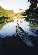 Tourist metal bongo on the Guaratico River
 -
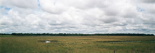 The flat Llanos
 -
 Wet season
 -
 Sunset
 -
 Thunderstorm tracks
.jpg)


Cities in the Llanos[change | change source]
In Colombia[change | change source]
- Acacías
- Arauca, Arauca
- Gaviotas
- Maní, Casanare
- Orocué
- Paz de Ariporo
- Puerto Carreño
- Inírida
- Puerto López, Meta
- San José del Guaviare
- Saravena
- Tame
- Villavicencio
- Yopal
- Fortul
In Venezuela[change | change source]
- Acarigua
- Araure
- Barinas
- Calabozo
- Caripito
- El Tigre
- Guanare
- Maturín
- Puerto Ayacucho
- Sabaneta
- San Carlos
- San Fernando de Apure
- Tucupita
- Valle de la Pascua
Related pages[change | change source]
References[change | change source]
- ↑ 1.00 1.01 1.02 1.03 1.04 1.05 1.06 1.07 1.08 1.09 1.10 1.11 1.12 "Llanos". Terrestrial Ecoregions. World Wildlife Fund.
- ↑ 2.0 2.1 Earth. Doring Kindersley. 2003. pp. 328. ISBN 1-4053-0018-3.
- ↑ Jedrzejewski, W.; Abarca, M. R.; Viloria, Á.; Cerda, H.; Lew, D.; Takiff, H.; Abadia, E.; Velozo, P. (2011). "Jaguar conservation in Venezuela against the backdrop of current knowledge on its biology and evolution" (pdf). 36 (12). Interciencia: 954–966. Retrieved 2019-07-12.
{{cite journal}}: Cite journal requires|journal=(help) - ↑ Paz, Manuel María. "General View of The Plains, Province of Casanare". World Digital Library. Retrieved 2014-05-21.
- ↑ Eric Dinerstein, David Olson, et al. (2017). An Ecoregion-Based Approach to Protecting Half the Terrestrial Realm, BioScience, Volume 67, Issue 6, June 2017, Pages 534–545; Supplemental material 2 table S1b. [1]
- ↑ UNEP-WCMC (2020). Protected Area Profile for Venezuela (Bolivarian Republic of) from the World Database of Protected Areas, September 2020. Available at: www.protectedplanet.net
Other websites[change | change source]
- (in English) "Llanos". Terrestrial Ecoregions. World Wildlife Fund.
- (in English) Dawn on the Plains Photo Feature, Havana Times, Oct 1, 2010.
- (in Spanish) The llanos music
- (in Spanish) The llanos of Colombia and Venezuela
- (in Spanish) Los Llanos de Colombia
| Authority control: National |
|---|