
Mädelegabel
| Mädelegabel | |
|---|---|
 The Mädelegabel from the south. Below: the Schwarzmilzferner (2009) | |
| Highest point | |
| Elevation | 2645m |
| Prominence | 81 m ↓ Windgap with the Hochfrottspitze → Hochfrottspitze |
| Isolation | 0.4 km → Hochfrottspitze |
| Coordinates | 47°18′00″N 10°17′45″E / 47.3°N 10.29583°E |
| Geography | |
 Mädelegabel | |
| Parent range | Central Ridge, Allgäu Alps |
| Climbing | |
| First ascent | 1818 |
| Easiest route | from the Heilbronn Way |
The Mädelegabel is a mountain on the border of Austria and Germany. It is near Oberstdorf in the Allgäu Alps. It is one of the most-famous and most-climbed high mountains in the German Alps.
Mädelegabel is 2,645 metres (8,678 ft) high and made of Dolomite. It is the fourth tallest mountain in the Allgäu Alps, with a 400m tall rock face. With the Trettachspitze and the Hochfrottspitze, the Mädelegabel makes up the well known trio of peaks on the main ridge of the Allgäu Alps. Originally Mädelegabel was the name for all three mountains of the trio. Only later were they given different names. On its southeastern slopes is the Schwarzmilzferner, a small glacier. It was first climbed in 1818, by a survey team.
-
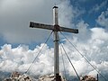 The summit cross
 -
 The Mädelegabel group from the Guggersee to the northwest
 -
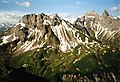 View of the Mädelegabel (2nd peak from right)


