M'Sila Province
M'Sila Province
ولاية المسيلة | |
|---|---|
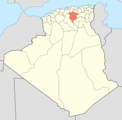
 Map of Algeria highlighting M'Sila | |
| Coordinates: 35°42′N 4°33′E / 35.700°N 4.550°E | |
| Country | Algeria |
| Capital | M'Sila |
| Area | |
| • Total | 18,718 km2 (7,227 sq mi) |
| Population (2008)[1] | |
| • Total | 991,846 |
| • Density | 53/km2 (140/sq mi) |
| Time zone | UTC+01 (CET) |
| Area Code | +213 (0) 35 |
| ISO 3166 code | DZ-28 |
| Districts | 15 |
| Municipalities | 47 |
M'Sila (also spelled Msila, M'sila or MSila) is a province of northern Algeria. It has 1 million people. The capital is also called M'sila. M'Sila is mostly known for its farming.
Divisions[change | change source]
The province has 15 districts and 47 communes or municipalities.
Districts[change | change source]
- Aïn El Hadjel
- Aïn El Melh
- Ben S'Rour
- Bou Saâda
- Chellal
- Djebel Messaâd
- Hammam Dhalaâ
- Khoubana
- M'Sila
- Magra
- Medjedel
- Ouled Derradj
- Ouled Sidi Brahim
- Sidi Aïssa
- Sidi Ameur
References[change | change source]
- ↑ Office National des Statistiques, Recensement General de la Population et de l’Habitat 2008 Preliminary results of the 2008 population census. Accessed on 2008-07-02.
