Ma'an
Ma'an
مدينة معان | |
|---|---|
City | |
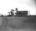
 A pre-1920 photograph of the train station in Ma'an. The Hejaz Railway is still operational today. | |
| Nickname: Capital of the Great Arab Revolt | |
| Coordinates: 30°11.6′N 35°44′E / 30.1933°N 35.733°E | |
| Country | Jordan |
| Governorate | Ma'an Governorate |
| Municipality established | 1898 |
| Government | |
| • Type | Municipality |
| • Mayor | Akram Kreishan |
| Area | |
| • City | 7.5 km2 (2.9 sq mi) |
| • Metro | 100 km2 (40 sq mi) |
| Population (2015)[1] | |
| • City | 41,055 |
| Time zone | GMT +2 |
| • Summer (DST) | +3 |
| Area code | +(962)3 |
| Website | http://www.maan.gov.jo |
Ma'an is a Jordanian city located in the southern part of the country on the western outskirts of the desert plateau extending from the Arabian Peninsula to the Levant desert.
It has a population of about 50 thousand and the area of the city is twenty square kilometers. Ma'an has a desert climate, where the temperature rises in summer to 35°C and drops to 15°C in winter. As for the winter rains, they are irregular, with a maximum of 60 mm. The city is affected in summer by southeast desert winds and winter by westerly winds which causes rain.
References[change | change source]
- ↑ "The General Census - 2015" (PDF). Department of Population Statistics.


