
Maynard, Arkansas
Maynard, Arkansas | |
|---|---|
 Location of Maynard in Randolph County, Arkansas. | |
| Coordinates: 36°25′17″N 90°54′07″W / 36.42139°N 90.90194°W | |
| Country | United States |
| State | Arkansas |
| County | Randolph |
| Government | |
| • Mayor | Gary Hart |
| Area | |
| • Total | 1.17 sq mi (3.03 km2) |
| • Land | 1.17 sq mi (3.03 km2) |
| • Water | 0.00 sq mi (0.00 km2) |
| Elevation | 433 ft (132 m) |
| Population (2020) | |
| • Total | 379 |
| • Density | 323.65/sq mi (124.97/km2) |
| Time zone | UTC-6 (Central (CST)) |
| • Summer (DST) | UTC-5 (CDT) |
| ZIP code | 72444 |
| Area code | 870 |
| FIPS code | 05-44780 |
| GNIS feature ID | 2406114[2] |
Maynard is a town in the US state of Arkansas.
References[change | change source]
- ↑ "2020 U.S. Gazetteer Files". United States Census Bureau. Retrieved October 29, 2021.
- ↑ 2.0 2.1 U.S. Geological Survey Geographic Names Information System: Maynard, Arkansas
Municipalities and communities of Randolph County, Arkansas, United States | ||
|---|---|---|
| Cities | 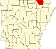 | |
| Towns | ||
| Townships | ||
| CDP | ||
| Other unincorporated communities | ||
| Ghost town | ||