McCloud, California
McCloud | |
|---|---|
 Deep snow in McCloud, with Mount Shasta in the background, December 2012 | |
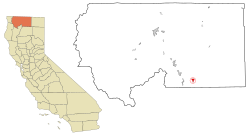
 Location in Siskiyou County and the state of California | |
| Coordinates: 41°15′17″N 122°8′11″W / 41.25472°N 122.13639°W | |
| Country | |
| State | |
| County | |
| Area | |
| • Total | 2.488 sq mi (6.444 km2) |
| • Land | 2.422 sq mi (6.274 km2) |
| • Water | 0.066 sq mi (0.171 km2) 2.65% |
| Elevation | 3,271 ft (997 m) |
| Population (2020)[3] | |
| • Total | 945 |
| • Density | 380/sq mi (150/km2) |
| Time zone | UTC-8 (Pacific (PST)) |
| • Summer (DST) | UTC-7 (PDT) |
| ZIP code | 96057 |
| Area code | 530 |
| FIPS code | 06-44784 |
| GNIS feature ID | 0277555 |
McCloud is a census-designated place (CDP) in Siskiyou County, California, United States. The population was 945 at the 2020 census.[3] It is found along California State Route 89.
References[change | change source]
- ↑ "U.S. Census". Archived from the original on January 25, 2012.
- ↑ "McCloud". Geographic Names Information System. United States Geological Survey. 1981-01-19. Retrieved 2012-12-27.
- ↑ 3.0 3.1 "McCloud CDP, California". United States Census Bureau. Retrieved August 29, 2023.


