Mojanda
| Mojanda | |
|---|---|
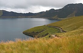
 Caricocha in the Mojanda caldera. On the opposite side of lake, the páramo has been burned away to promote new growth for cattle grazing. | |
| Highest point | |
| Elevation | 4,263 m (13,986 ft) |
| Prominence | 1,051 m (3,448 ft) |
| Coordinates | 0°08′N 78°16′W / 0.13°N 78.27°W |
| Geography | |
| Location | Between Imbabura Province and Pichincha Province, Ecuador |
| Parent range | Andes |
| Geology | |
| Mountain type | Inactive stratovolcano |
| Last eruption | Middle Pleistocene |
Mojanda is an inactive stratovolcano of the Eastern Cordillera of the Andes in northern Ecuador. It has three crater lakes: Karikucha (the largest), Yanakucha, and Warmikucha.[1]
References[change | change source]
- ↑ "Potential hazards in case of unrest at Mojanda - Fuya Fuya volcanic complex, Ecuador" (DOC). Retrieved 2006-03-17.
