
Moju Chowdhury Hat
Moju Chowdhury Hat
মজু চৌধুরীর হাট | |
|---|---|
 Moju Chowdhury Hat at Sunrise. | |
| Nickname: MCH | |
 Moju Chowdhury Hat Location in Bangladesh | |
| Coordinates: 22°52′29″N 90°47′05″E / 22.8745967°N 90.7846910°E | |
| Country | Bangladesh |
| Division | Chittagong Division |
| District | Lakshmipur District |
| Upazila | Lakshmipur Sadar Upazila |
| Established in | 1965 |
| Funded by Moju Chowdhury | 1966 |
| Area | |
| • Total | 145.18 km2 (56.05 sq mi) |
| Elevation | 56.05 m (183.89 ft) |
| Population (2014) | |
| • Total | 42,000 |
| • Density | 56.05/km2 (145.18/sq mi) |
| Time zone | UTC+6 (BST) |
| postal code | 3700 |
| Website | Official Website of Moju Chowdhury Hat |
Moju Chowdhury Hat or Rahmat Khali is a town and tourism in Lakshmipur Sadar Upazila of Lakshmipur District,[1] in south-eastern Bangladesh. It is commonly known as Moju Chowdhury Hat but it used to be called Rahmat Khali. It was renamed Moju Chowdhury in 1965. It is spelled as M.C.H. for short [2] (Bengali: মজু চৌধুরীর হাট). This town is 12 km² south of Lakshmipur City. It is across the Meghna River from Bhola 38 km² to the southwest. Moju Chowdhury Hat is 76 km² east of Barisal. Moju Chowdhury Hat is itself municipality and a tourist destination. It is also a ransport hub for passengers from the Bhola Barisal Division and Chittagong Division, serving about four thousand people per day.
History[change | change source]
Moju Chowdhury is named after a person. Moju Chowdhury came to Rahmat Khali when it was still part of the Mughal Empire. Moju Chowdhury was the second of Pana Mia Hazi's four sons. He went to Lakshmipur Government Collage, where he studied landscapes.
Geography[change | change source]
Moju Chowdhury Hat is located at 22°52′29″N 90°47′05″E / 22.8745967°N 90.7846910°E It has 145.56 households and a total area of 56.05 km².
Gallery[change | change source]
-
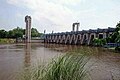 The New Sluice Gate and bridge
 -
 The bridge built in 1972–75
 -
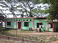
 West Boundary
 -
 Lillah Jame Mosque the first mosque in Moju Chowdhury Hat view from Mathir Hat Road
 -
 Saifia Darbar Sharif the Central mosque of Moju Chowdhury Hat
 -
 Old Sluice Gate and Bridge which are built in 1975 a first Bridge in Rahmat Khali areas
 -
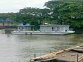 Bangladesh Coast Guard posted in Moju Chowdhury Hat 2010
 -
 Coast Guard station Bangladesh Navy forces present in Moju Chowdhury Hat with 85 Popularity and Administrations
 -
 Bus Station view from Lakshmipur Bhola Barisal Highway.
 -
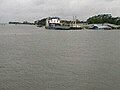 Ferry Terminal view from Old Sluice Gate


Related pages[change | change source]
- List of cities and towns in Bangladesh
- Divisions of Bangladesh
- Districts of Bangladesh
- Lakshmipur District
References[change | change source]
- ↑ "Unsafe water transports ply 'danger zone' defying ban". archive.thedailystar.net. 27 May 2011. Archived from the original on 2016-03-10. Retrieved 2016-03-10.
- ↑ Nazimuddin Mahmud (2012), "Lakshmipur Sadar Upazila", in Sirajul Islam and Ahmed A. Jamal (ed.), Banglapedia: National Encyclopedia of Bangladesh (Second ed.), Asiatic Society of Bangladesh
Other websites[change | change source]